You are here: Home > Network List > IU - Global Seismograph Network (GSN - IRIS/USGS) Stations List
> Station HKT Hockley, Texas > Earthquake Result Viewer
HKT Hockley, Texas - Earthquake Result Viewer
| Earthquake location: |
Norwegian Sea |
| Earthquake latitude/longitude: |
72.2/0.9 |
| Earthquake time(UTC): |
2009/08/20 (232) 06:35:04 GMT |
| Earthquake Depth: |
6.0 km |
| Earthquake Magnitude: |
5.9 MB, 5.7 MS, 6.0 MW, 6.0 MW |
| Earthquake Catalog/Contributor: |
WHDF/NEIC |
|
| Network: |
IU Global Seismograph Network (GSN - IRIS/USGS) |
| Station: |
HKT Hockley, Texas |
| Lat/Lon: |
29.96 N/95.84 W |
| Elevation: |
-413.0 m |
|
| Distance: |
63.8 deg |
| Az: |
286.2 deg |
| Baz: |
19.898 deg |
| Ray Param: |
0.059341036 |
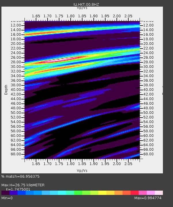
| Estimated Moho Depth: |
26.75 km |
| Estimated Crust Vp/Vs: |
1.75 |
| Assumed Crust Vp: |
5.581 km/s |
| Estimated Crust Vs: |
3.194 km/s |
| Estimated Crust Poisson's Ratio: |
0.26 |
|
| Radial Match: |
86.956375 % |
| Radial Bump: |
400 |
| Transverse Match: |
79.00718 % |
| Transverse Bump: |
326 |
| SOD ConfigId: |
2622 |
| Insert Time: |
2010-03-02 13:53:50.418 +0000 |
| GWidth: |
2.5 |
| Max Bumps: |
400 |
| Tol: |
0.001 |
|
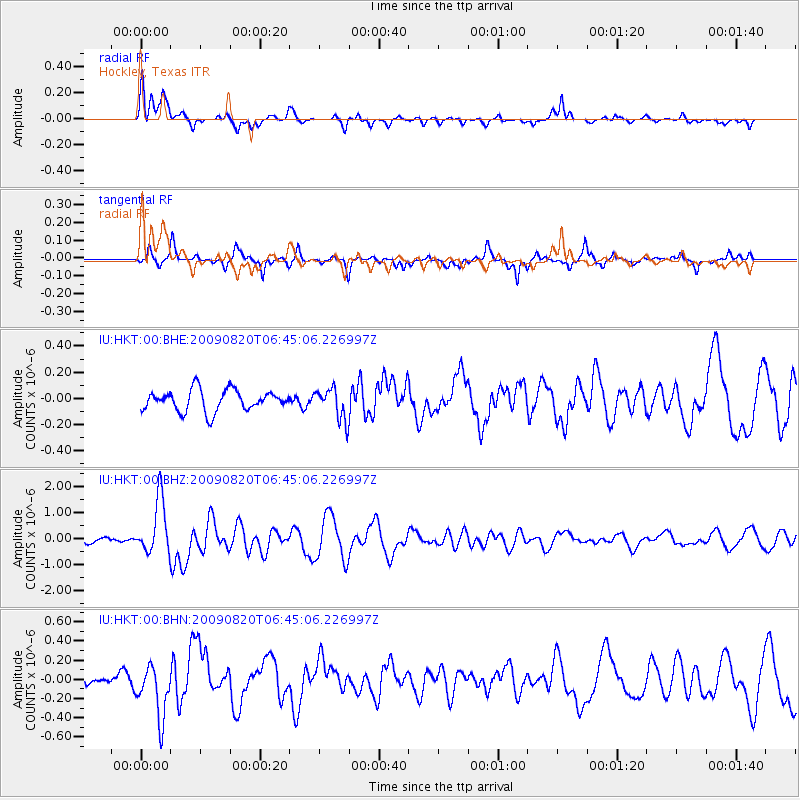
Signal To Noise
| Channel | StoN | STA | LTA |
| IU:HKT:00:BHZ:20090820T06:45:06.226997Z | 14.825962 | 1.054556E-6 | 7.112901E-8 |
| IU:HKT:00:BHN:20090820T06:45:06.226997Z | 5.7403474 | 2.7596354E-7 | 4.8074366E-8 |
| IU:HKT:00:BHE:20090820T06:45:06.226997Z | 1.5178758 | 1.2118144E-7 | 7.98362E-8 |
| Arrivals |
| Ps | 3.7 SECOND |
| PpPs | 13 SECOND |
| PsPs/PpSs | 16 SECOND |


