You are here: Home > Network List > AV - Alaska Volcano Observatory Stations List
> Station SPCR Ckakachatna River, Mount Spurr, Alaska > Earthquake Result Viewer
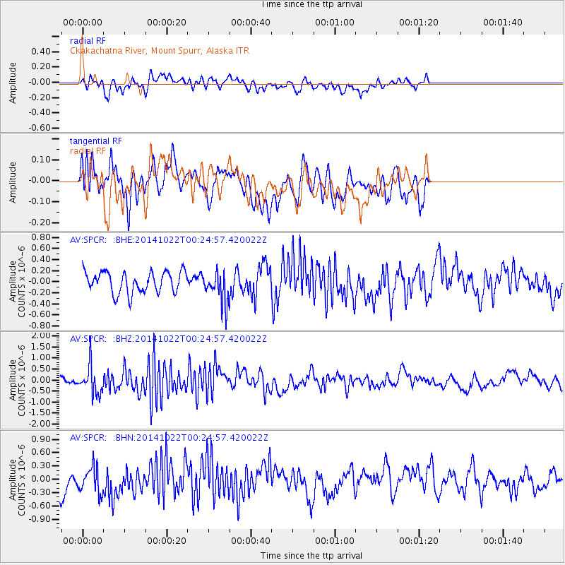
SPCR Ckakachatna River, Mount Spurr, Alaska - Earthquake Result Viewer
*The percent match for this event was below the threshold and hence no stack was calculated.
| Earthquake location: |
Ryukyu Islands, Japan |
| Earthquake latitude/longitude: |
27.5/128.4 |
| Earthquake time(UTC): |
2014/10/22 (295) 00:15:17 GMT |
| Earthquake Depth: |
42 km |
| Earthquake Magnitude: |
5.8 MB |
| Earthquake Catalog/Contributor: |
NEIC PDE/NEIC COMCAT |
|
| Network: |
AV Alaska Volcano Observatory |
| Station: |
SPCR Ckakachatna River, Mount Spurr, Alaska |
| Lat/Lon: |
61.20 N/152.21 W |
| Elevation: |
984 m |
|
| Distance: |
61.2 deg |
| Az: |
32.886 deg |
| Baz: |
275.175 deg |
| Ray Param: |
$rayparam |
*The percent match for this event was below the threshold and hence was not used in the summary stack. |
|
| Radial Match: |
55.942837 % |
| Radial Bump: |
400 |
| Transverse Match: |
49.03932 % |
| Transverse Bump: |
400 |
| SOD ConfigId: |
811408 |
| Insert Time: |
2014-11-05 00:29:28.123 +0000 |
| GWidth: |
2.5 |
| Max Bumps: |
400 |
| Tol: |
0.001 |
|
Signal To Noise
| Channel | StoN | STA | LTA |
| AV:SPCR: :BHZ:20141022T00:24:57.420022Z | 3.0480773 | 6.680942E-7 | 2.1918545E-7 |
| AV:SPCR: :BHN:20141022T00:24:57.420022Z | 1.3397152 | 3.0266418E-7 | 2.2591679E-7 |
| AV:SPCR: :BHE:20141022T00:24:57.420022Z | 1.5365666 | 2.935674E-7 | 1.9105414E-7 |
| Arrivals |
| Ps | |
| PpPs | |
| PsPs/PpSs | |


