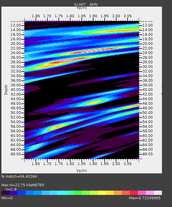
HKT Hockley, Texas - Earthquake Result Viewer
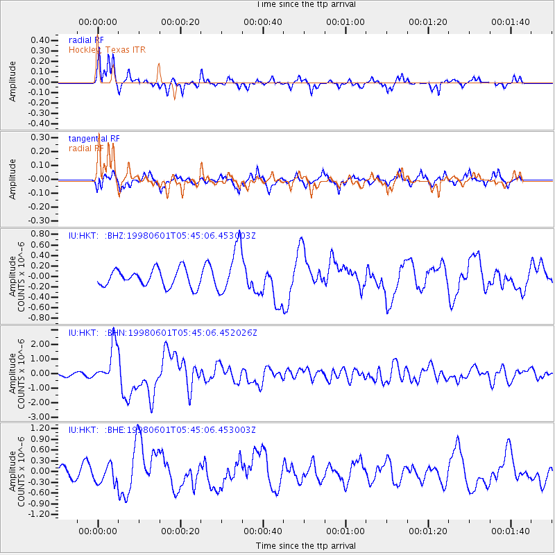
Earthquake location: Off East Coast Of Kamchatka
Earthquake latitude/longitude: 52.9/160.1
Earthquake time(UTC): 1998/06/01 (152) 05:34:03 GMT
Earthquake Depth: 44 km
Earthquake Magnitude: 6.2 MB, 6.3 MS, 6.5 UNKNOWN, 6.4 MW
Earthquake Catalog/Contributor: WHDF/NEIC
Network: IU Global Seismograph Network (GSN - IRIS/USGS)
Station: HKT Hockley, Texas
Lat/Lon: 29.96 N/95.84 W
Elevation: -413.0 m
Distance: 74.5 deg
Az: 60.862 deg
Baz: 322.419 deg
Ray Param: 0.052214116
Estimated Moho Depth: 22.75 km
Estimated Crust Vp/Vs: 1.90
Assumed Crust Vp: 5.581 km/s
Estimated Crust Vs: 2.938 km/s
Estimated Crust Poisson's Ratio: 0.31
Radial Match: 84.40264 %
Radial Bump: 297
Transverse Match: 60.262398 %
Transverse Bump: 362
SOD ConfigId: 4480
Insert Time: 2010-03-02 13:54:01.157 +0000
GWidth: 2.5
Max Bumps: 400
Tol: 0.001

Signal To Noise

ChannelStoNSTALTA
IU:HKT: :BHN:19980601T05:45:06.452026Z10.378691.3875217E-61.3368948E-7
IU:HKT: :BHE:19980601T05:45:06.453003Z1.14194892.6088242E-72.2845367E-7
IU:HKT: :BHZ:19980601T05:45:06.453003Z2.885884.6793136E-71.6214511E-7
Arrivals
Ps3.8 SECOND
PpPs12 SECOND
PsPs/PpSs15 SECOND