You are here: Home > Network List > IU - Global Seismograph Network (GSN - IRIS/USGS) Stations List
> Station HKT Hockley, Texas > Earthquake Result Viewer
HKT Hockley, Texas - Earthquake Result Viewer
| Earthquake location: |
Near Coast Of Central Chile |
| Earthquake latitude/longitude: |
-32.3/-71.3 |
| Earthquake time(UTC): |
1998/07/29 (210) 07:14:24 GMT |
| Earthquake Depth: |
51 km |
| Earthquake Magnitude: |
6.3 MB, 6.5 UNKNOWN, 6.5 ME |
| Earthquake Catalog/Contributor: |
WHDF/NEIC |
|
| Network: |
IU Global Seismograph Network (GSN - IRIS/USGS) |
| Station: |
HKT Hockley, Texas |
| Lat/Lon: |
29.96 N/95.84 W |
| Elevation: |
-413.0 m |
|
| Distance: |
66.2 deg |
| Az: |
336.784 deg |
| Baz: |
157.378 deg |
| Ray Param: |
0.057685576 |
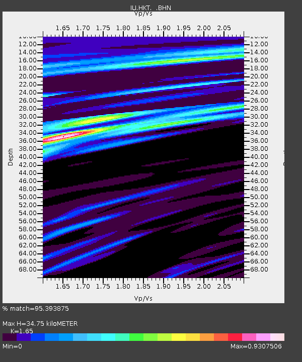
| Estimated Moho Depth: |
34.75 km |
| Estimated Crust Vp/Vs: |
1.65 |
| Assumed Crust Vp: |
5.581 km/s |
| Estimated Crust Vs: |
3.383 km/s |
| Estimated Crust Poisson's Ratio: |
0.21 |
|
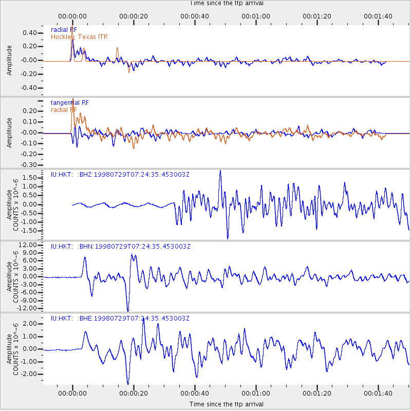
| Radial Match: |
95.393875 % |
| Radial Bump: |
392 |
| Transverse Match: |
86.52046 % |
| Transverse Bump: |
400 |
| SOD ConfigId: |
4480 |
| Insert Time: |
2010-03-02 13:54:12.774 +0000 |
| GWidth: |
2.5 |
| Max Bumps: |
400 |
| Tol: |
0.001 |
|
Signal To Noise
| Channel | StoN | STA | LTA |
| IU:HKT: :BHN:19980729T07:24:35.453003Z | 49.98337 | 2.8148572E-6 | 5.6315876E-8 |
| IU:HKT: :BHE:19980729T07:24:35.453003Z | 15.885499 | 6.1240746E-7 | 3.8551352E-8 |
| IU:HKT: :BHZ:19980729T07:24:35.453003Z | 4.740778 | 3.6269685E-7 | 7.650577E-8 |
| Arrivals |
| Ps | 4.2 SECOND |
| PpPs | 16 SECOND |
| PsPs/PpSs | 20 SECOND |


