You are here: Home > Network List > XD14 - Illuminating the architecture of the greater Mount St. Helens magmatic systems f Stations List
> Station MN10 "Mount St Helens, WA" > Earthquake Result Viewer
MN10 "Mount St Helens, WA" - Earthquake Result Viewer
| Earthquake location: |
Solomon Islands |
| Earthquake latitude/longitude: |
-7.3/154.5 |
| Earthquake time(UTC): |
2015/05/07 (127) 07:10:22 GMT |
| Earthquake Depth: |
22 km |
| Earthquake Magnitude: |
7.2 MWP, 7.2 MI |
| Earthquake Catalog/Contributor: |
NEIC PDE/NEIC COMCAT |
|
| Network: |
XD Illuminating the architecture of the greater Mount St. Helens magmatic systems f |
| Station: |
MN10 "Mount St Helens, WA" |
| Lat/Lon: |
45.98 N/121.68 W |
| Elevation: |
1091 m |
|
| Distance: |
90.9 deg |
| Az: |
43.89 deg |
| Baz: |
260.518 deg |
| Ray Param: |
0.04164007 |
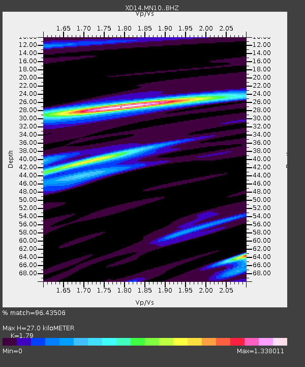
| Estimated Moho Depth: |
27.0 km |
| Estimated Crust Vp/Vs: |
1.79 |
| Assumed Crust Vp: |
6.597 km/s |
| Estimated Crust Vs: |
3.686 km/s |
| Estimated Crust Poisson's Ratio: |
0.27 |
|
| Radial Match: |
96.43506 % |
| Radial Bump: |
349 |
| Transverse Match: |
74.26062 % |
| Transverse Bump: |
400 |
| SOD ConfigId: |
7422571 |
| Insert Time: |
2019-04-18 17:26:46.432 +0000 |
| GWidth: |
2.5 |
| Max Bumps: |
400 |
| Tol: |
0.001 |
|

Signal To Noise
| Channel | StoN | STA | LTA |
| XD:MN10: :BHZ:20150507T07:22:52.260027Z | 3.4132802 | 7.987556E-7 | 2.3401407E-7 |
| XD:MN10: :BHN:20150507T07:22:52.260027Z | 1.2155982 | 2.6814416E-7 | 2.2058617E-7 |
| XD:MN10: :BHE:20150507T07:22:52.260027Z | 0.6625408 | 1.9477608E-7 | 2.939835E-7 |
| Arrivals |
| Ps | 3.3 SECOND |
| PpPs | 11 SECOND |
| PsPs/PpSs | 14 SECOND |


