You are here: Home > Network List > XD14 - Illuminating the architecture of the greater Mount St. Helens magmatic systems f Stations List
> Station MP04 "Mount St Helens, WA" > Earthquake Result Viewer
MP04 "Mount St Helens, WA" - Earthquake Result Viewer
| Earthquake location: |
Solomon Islands |
| Earthquake latitude/longitude: |
-7.3/154.5 |
| Earthquake time(UTC): |
2015/05/07 (127) 07:10:22 GMT |
| Earthquake Depth: |
22 km |
| Earthquake Magnitude: |
7.2 MWP, 7.2 MI |
| Earthquake Catalog/Contributor: |
NEIC PDE/NEIC COMCAT |
|
| Network: |
XD Illuminating the architecture of the greater Mount St. Helens magmatic systems f |
| Station: |
MP04 "Mount St Helens, WA" |
| Lat/Lon: |
45.81 N/122.38 W |
| Elevation: |
497 m |
|
| Distance: |
90.4 deg |
| Az: |
43.975 deg |
| Baz: |
260.015 deg |
| Ray Param: |
0.041676503 |
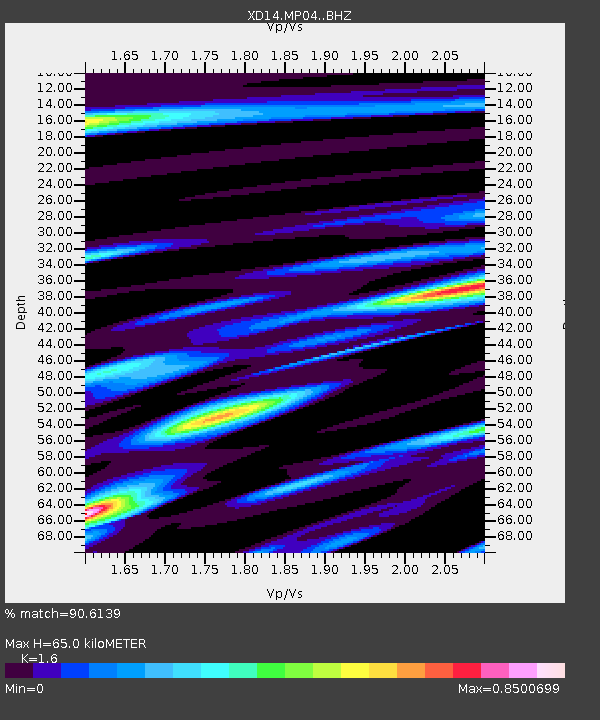
| Estimated Moho Depth: |
65.0 km |
| Estimated Crust Vp/Vs: |
1.60 |
| Assumed Crust Vp: |
6.566 km/s |
| Estimated Crust Vs: |
4.104 km/s |
| Estimated Crust Poisson's Ratio: |
0.18 |
|
| Radial Match: |
90.6139 % |
| Radial Bump: |
400 |
| Transverse Match: |
68.851326 % |
| Transverse Bump: |
400 |
| SOD ConfigId: |
7422571 |
| Insert Time: |
2019-04-18 17:26:51.032 +0000 |
| GWidth: |
2.5 |
| Max Bumps: |
400 |
| Tol: |
0.001 |
|

Signal To Noise
| Channel | StoN | STA | LTA |
| XD:MP04: :BHZ:20150507T07:22:49.889971Z | 3.864855 | 8.9582863E-7 | 2.3178842E-7 |
| XD:MP04: :BHN:20150507T07:22:49.889971Z | 0.62842906 | 1.15862406E-7 | 1.8436832E-7 |
| XD:MP04: :BHE:20150507T07:22:49.889971Z | 2.1927843 | 3.7401088E-7 | 1.7056438E-7 |
| Arrivals |
| Ps | 6.1 SECOND |
| PpPs | 25 SECOND |
| PsPs/PpSs | 31 SECOND |


