You are here: Home > Network List > XL12 - Hangay Dome, Mongolia Stations List
> Station AT12 AT12 > Earthquake Result Viewer
AT12 AT12 - Earthquake Result Viewer
| Earthquake location: |
Solomon Islands |
| Earthquake latitude/longitude: |
-7.3/154.5 |
| Earthquake time(UTC): |
2015/05/07 (127) 07:10:22 GMT |
| Earthquake Depth: |
22 km |
| Earthquake Magnitude: |
7.2 MWP, 7.2 MI |
| Earthquake Catalog/Contributor: |
NEIC PDE/NEIC COMCAT |
|
| Network: |
XL Hangay Dome, Mongolia |
| Station: |
AT12 AT12 |
| Lat/Lon: |
44.66 N/96.01 E |
| Elevation: |
1596 m |
|
| Distance: |
73.6 deg |
| Az: |
320.637 deg |
| Baz: |
118.151 deg |
| Ray Param: |
0.05283978 |
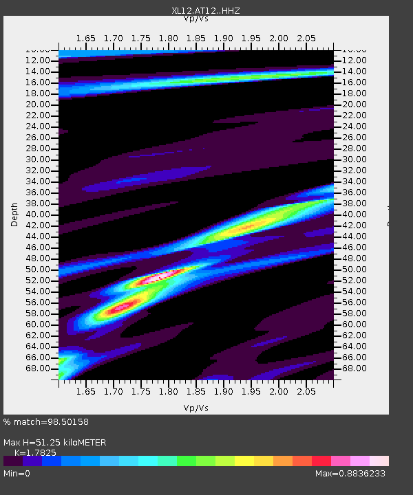
| Estimated Moho Depth: |
51.25 km |
| Estimated Crust Vp/Vs: |
1.78 |
| Assumed Crust Vp: |
6.353 km/s |
| Estimated Crust Vs: |
3.564 km/s |
| Estimated Crust Poisson's Ratio: |
0.27 |
|
| Radial Match: |
98.50158 % |
| Radial Bump: |
221 |
| Transverse Match: |
92.971085 % |
| Transverse Bump: |
400 |
| SOD ConfigId: |
7422571 |
| Insert Time: |
2019-04-18 17:27:02.498 +0000 |
| GWidth: |
2.5 |
| Max Bumps: |
400 |
| Tol: |
0.001 |
|

Signal To Noise
| Channel | StoN | STA | LTA |
| XL:AT12: :HHZ:20150507T07:21:22.729998Z | 46.528202 | 1.907672E-6 | 4.1000337E-8 |
| XL:AT12: :HHN:20150507T07:21:22.729998Z | 3.621073 | 2.506772E-7 | 6.9227326E-8 |
| XL:AT12: :HHE:20150507T07:21:22.729998Z | 14.636674 | 5.260878E-7 | 3.5943124E-8 |
| Arrivals |
| Ps | 6.5 SECOND |
| PpPs | 22 SECOND |
| PsPs/PpSs | 28 SECOND |


