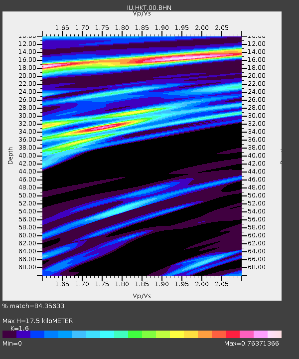
HKT Hockley, Texas - Earthquake Result Viewer
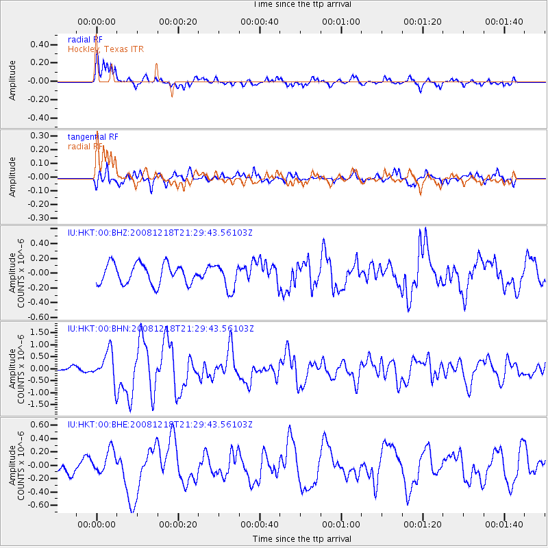
Earthquake location: Near Coast Of Central Chile
Earthquake latitude/longitude: -32.5/-71.7
Earthquake time(UTC): 2008/12/18 (353) 21:19:28 GMT
Earthquake Depth: 18 km
Earthquake Magnitude: 5.8 MB, 6.0 MS, 6.2 MW, 6.1 MW
Earthquake Catalog/Contributor: WHDF/NEIC
Network: IU Global Seismograph Network (GSN - IRIS/USGS)
Station: HKT Hockley, Texas
Lat/Lon: 29.96 N/95.84 W
Elevation: -413.0 m
Distance: 66.2 deg
Az: 337.195 deg
Baz: 157.815 deg
Ray Param: 0.057783373
Estimated Moho Depth: 17.5 km
Estimated Crust Vp/Vs: 1.60
Assumed Crust Vp: 5.581 km/s
Estimated Crust Vs: 3.488 km/s
Estimated Crust Poisson's Ratio: 0.18
Radial Match: 84.35633 %
Radial Bump: 379
Transverse Match: 70.4452 %
Transverse Bump: 400
SOD ConfigId: 2658
Insert Time: 2010-03-02 13:54:31.078 +0000
GWidth: 2.5
Max Bumps: 400
Tol: 0.001

Signal To Noise

ChannelStoNSTALTA
IU:HKT:00:BHN:20081218T21:29:43.56103Z5.9226366.7994773E-71.1480491E-7
IU:HKT:00:BHE:20081218T21:29:43.56103Z1.54672541.8126518E-71.1719286E-7
IU:HKT:00:BHZ:20081218T21:29:43.56103Z1.34283011.7971792E-71.338352E-7
Arrivals
Ps1.9 SECOND
PpPs7.9 SECOND
PsPs/PpSs9.8 SECOND