You are here: Home > Network List > TA - USArray Transportable Network (new EarthScope stations) Stations List
> Station I23K Minto, Yukon-Koyukuk, AK, USA > Earthquake Result Viewer
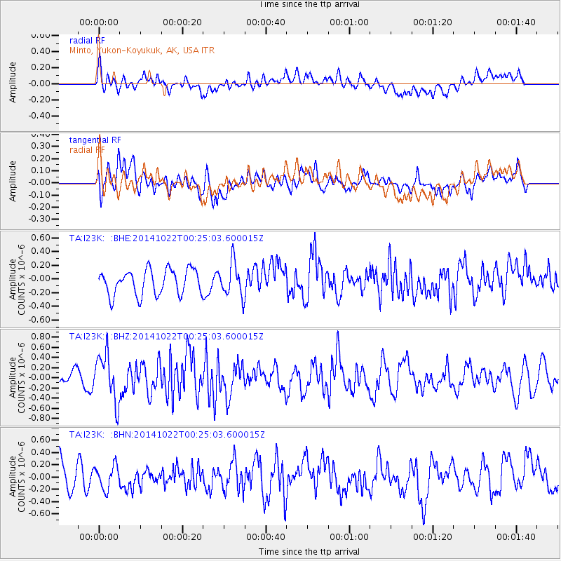
I23K Minto, Yukon-Koyukuk, AK, USA - Earthquake Result Viewer
*The percent match for this event was below the threshold and hence no stack was calculated.
| Earthquake location: |
Ryukyu Islands, Japan |
| Earthquake latitude/longitude: |
27.5/128.4 |
| Earthquake time(UTC): |
2014/10/22 (295) 00:15:17 GMT |
| Earthquake Depth: |
42 km |
| Earthquake Magnitude: |
5.8 MB |
| Earthquake Catalog/Contributor: |
NEIC PDE/NEIC COMCAT |
|
| Network: |
TA USArray Transportable Network (new EarthScope stations) |
| Station: |
I23K Minto, Yukon-Koyukuk, AK, USA |
| Lat/Lon: |
65.15 N/149.36 W |
| Elevation: |
149 m |
|
| Distance: |
62.1 deg |
| Az: |
28.268 deg |
| Baz: |
275.523 deg |
| Ray Param: |
$rayparam |
*The percent match for this event was below the threshold and hence was not used in the summary stack. |
|
| Radial Match: |
49.86545 % |
| Radial Bump: |
400 |
| Transverse Match: |
51.374805 % |
| Transverse Bump: |
400 |
| SOD ConfigId: |
811408 |
| Insert Time: |
2014-11-05 00:43:35.426 +0000 |
| GWidth: |
2.5 |
| Max Bumps: |
400 |
| Tol: |
0.001 |
|
Signal To Noise
| Channel | StoN | STA | LTA |
| TA:I23K: :BHZ:20141022T00:25:03.600015Z | 2.732524 | 4.7618724E-7 | 1.7426645E-7 |
| TA:I23K: :BHN:20141022T00:25:03.600015Z | 0.83920884 | 1.9287695E-7 | 2.2983188E-7 |
| TA:I23K: :BHE:20141022T00:25:03.600015Z | 1.3656847 | 2.5050926E-7 | 1.8343125E-7 |
| Arrivals |
| Ps | |
| PpPs | |
| PsPs/PpSs | |


