You are here: Home > Network List > UU - University of Utah Regional Network Stations List
> Station KNB Kanab, UT, USA > Earthquake Result Viewer
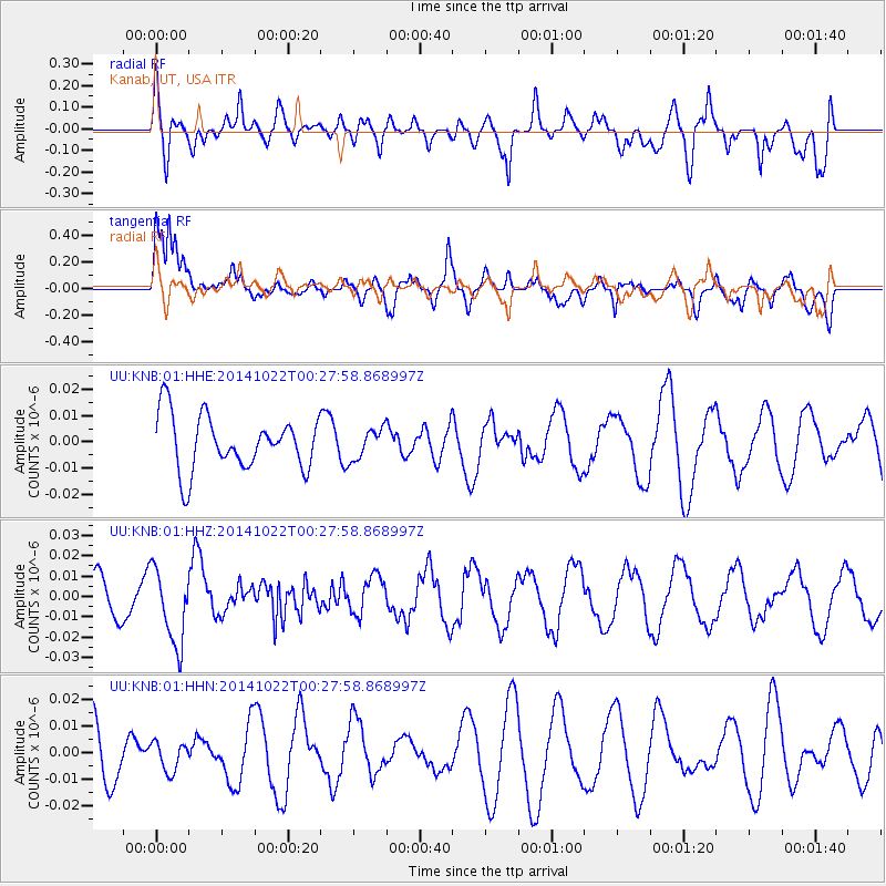
KNB Kanab, UT, USA - Earthquake Result Viewer
*The percent match for this event was below the threshold and hence no stack was calculated.
| Earthquake location: |
Ryukyu Islands, Japan |
| Earthquake latitude/longitude: |
27.5/128.4 |
| Earthquake time(UTC): |
2014/10/22 (295) 00:15:17 GMT |
| Earthquake Depth: |
42 km |
| Earthquake Magnitude: |
5.8 MB |
| Earthquake Catalog/Contributor: |
NEIC PDE/NEIC COMCAT |
|
| Network: |
UU University of Utah Regional Network |
| Station: |
KNB Kanab, UT, USA |
| Lat/Lon: |
37.02 N/112.82 W |
| Elevation: |
1715 m |
|
| Distance: |
93.8 deg |
| Az: |
44.691 deg |
| Baz: |
308.7 deg |
| Ray Param: |
$rayparam |
*The percent match for this event was below the threshold and hence was not used in the summary stack. |
|
| Radial Match: |
56.08697 % |
| Radial Bump: |
400 |
| Transverse Match: |
67.873795 % |
| Transverse Bump: |
400 |
| SOD ConfigId: |
811408 |
| Insert Time: |
2014-11-05 00:44:24.271 +0000 |
| GWidth: |
2.5 |
| Max Bumps: |
400 |
| Tol: |
0.001 |
|
Signal To Noise
| Channel | StoN | STA | LTA |
| UU:KNB:01:HHZ:20141022T00:27:58.868997Z | 1.9774288 | 1.8518515E-8 | 9.364946E-9 |
| UU:KNB:01:HHN:20141022T00:27:58.868997Z | 0.6543942 | 5.5148646E-9 | 8.427435E-9 |
| UU:KNB:01:HHE:20141022T00:27:58.868997Z | 0.5622787 | 5.8215837E-9 | 1.0353555E-8 |
| Arrivals |
| Ps | |
| PpPs | |
| PsPs/PpSs | |


