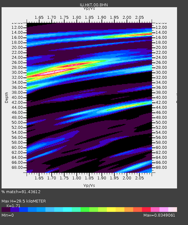
HKT Hockley, Texas - Earthquake Result Viewer
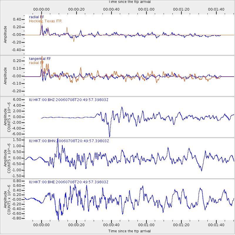
Earthquake location: Andreanof Islands, Aleutian Is.
Earthquake latitude/longitude: 51.2/-179.3
Earthquake time(UTC): 2006/07/08 (189) 20:40:00 GMT
Earthquake Depth: 22 km
Earthquake Magnitude: 6.2 MB, 6.4 MS, 6.6 MW, 6.6 MW
Earthquake Catalog/Contributor: WHDF/NEIC
Network: IU Global Seismograph Network (GSN - IRIS/USGS)
Station: HKT Hockley, Texas
Lat/Lon: 29.96 N/95.84 W
Elevation: -413.0 m
Distance: 63.4 deg
Az: 74.701 deg
Baz: 315.646 deg
Ray Param: 0.059599616
Estimated Moho Depth: 29.5 km
Estimated Crust Vp/Vs: 1.71
Assumed Crust Vp: 5.581 km/s
Estimated Crust Vs: 3.264 km/s
Estimated Crust Poisson's Ratio: 0.24
Radial Match: 91.43612 %
Radial Bump: 400
Transverse Match: 81.182755 %
Transverse Bump: 400
SOD ConfigId: 5423
Insert Time: 2010-03-02 13:54:36.101 +0000
GWidth: 2.5
Max Bumps: 400
Tol: 0.001

Signal To Noise

ChannelStoNSTALTA
IU:HKT:00:BHN:20060708T20:49:57.39803Z4.1107472.722238E-76.622246E-8
IU:HKT:00:BHE:20060708T20:49:57.39803Z2.12657281.7096494E-78.0394585E-8
IU:HKT:00:BHZ:20060708T20:49:57.39803Z10.8039159.260757E-78.571668E-8
Arrivals
Ps3.9 SECOND
PpPs14 SECOND
PsPs/PpSs18 SECOND