You are here: Home > Network List > CI - Caltech Regional Seismic Network Stations List
> Station CWC Cottonwood Creek, Lone Pine, CA, USA > Earthquake Result Viewer
CWC Cottonwood Creek, Lone Pine, CA, USA - Earthquake Result Viewer
| Earthquake location: |
Solomon Islands |
| Earthquake latitude/longitude: |
-8.5/157.0 |
| Earthquake time(UTC): |
2007/04/01 (091) 20:39:56 GMT |
| Earthquake Depth: |
10 km |
| Earthquake Magnitude: |
6.8 MB, 7.9 MS, 8.1 MW, 7.7 ME |
| Earthquake Catalog/Contributor: |
WHDF/NEIC |
|
| Network: |
CI Caltech Regional Seismic Network |
| Station: |
CWC Cottonwood Creek, Lone Pine, CA, USA |
| Lat/Lon: |
36.44 N/118.08 W |
| Elevation: |
1595 m |
|
| Distance: |
90.9 deg |
| Az: |
53.442 deg |
| Baz: |
260.205 deg |
| Ray Param: |
0.041642547 |
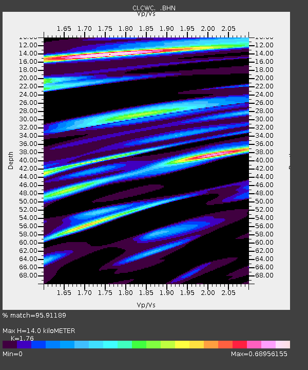
| Estimated Moho Depth: |
14.0 km |
| Estimated Crust Vp/Vs: |
1.76 |
| Assumed Crust Vp: |
6.291 km/s |
| Estimated Crust Vs: |
3.575 km/s |
| Estimated Crust Poisson's Ratio: |
0.26 |
|
| Radial Match: |
95.91189 % |
| Radial Bump: |
400 |
| Transverse Match: |
89.85881 % |
| Transverse Bump: |
400 |
| SOD ConfigId: |
2564 |
| Insert Time: |
2010-02-25 21:20:22.877 +0000 |
| GWidth: |
2.5 |
| Max Bumps: |
400 |
| Tol: |
0.001 |
|
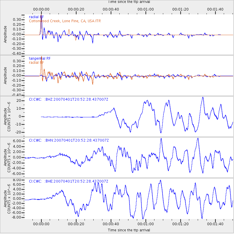
Signal To Noise
| Channel | StoN | STA | LTA |
| CI:CWC: :BHN:20070401T20:52:28.437007Z | 0.92270184 | 5.2212454E-7 | 5.6586487E-7 |
| CI:CWC: :BHE:20070401T20:52:28.437007Z | 0.413271 | 2.366452E-7 | 5.726151E-7 |
| CI:CWC: :BHZ:20070401T20:52:28.437007Z | 8.349068 | 1.3561267E-6 | 1.6242852E-7 |
| Arrivals |
| Ps | 1.7 SECOND |
| PpPs | 6.0 SECOND |
| PsPs/PpSs | 7.7 SECOND |


