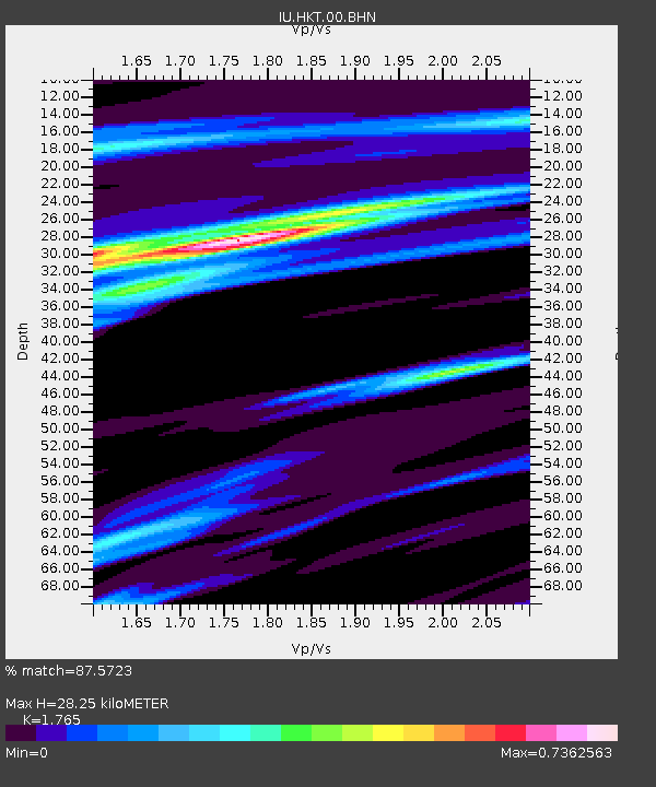
HKT Hockley, Texas - Earthquake Result Viewer
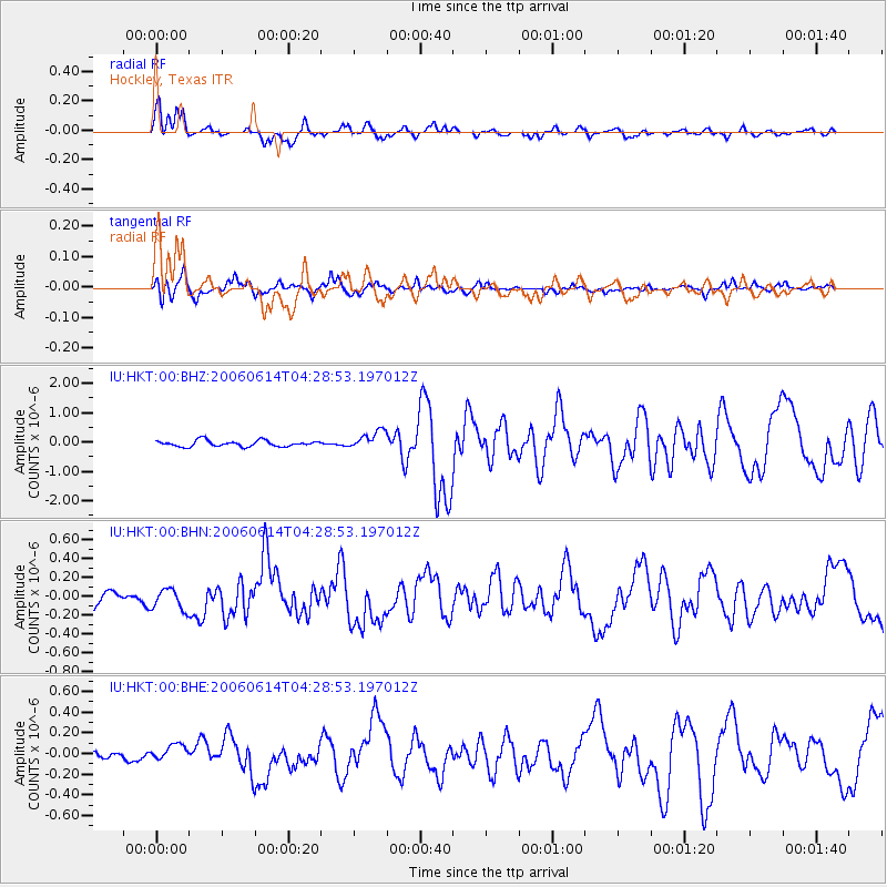
Earthquake location: Rat Islands, Aleutian Islands
Earthquake latitude/longitude: 51.8/177.1
Earthquake time(UTC): 2006/06/14 (165) 04:18:42 GMT
Earthquake Depth: 14 km
Earthquake Magnitude: 5.9 MB, 6.4 MS, 6.4 MW, 6.4 MW
Earthquake Catalog/Contributor: WHDF/NEIC
Network: IU Global Seismograph Network (GSN - IRIS/USGS)
Station: HKT Hockley, Texas
Lat/Lon: 29.96 N/95.84 W
Elevation: -413.0 m
Distance: 65.4 deg
Az: 72.44 deg
Baz: 316.926 deg
Ray Param: 0.058306362
Estimated Moho Depth: 28.25 km
Estimated Crust Vp/Vs: 1.76
Assumed Crust Vp: 5.581 km/s
Estimated Crust Vs: 3.162 km/s
Estimated Crust Poisson's Ratio: 0.26
Radial Match: 87.5723 %
Radial Bump: 400
Transverse Match: 84.141884 %
Transverse Bump: 400
SOD ConfigId: 5745
Insert Time: 2010-03-02 13:54:45.268 +0000
GWidth: 2.5
Max Bumps: 400
Tol: 0.001

Signal To Noise

ChannelStoNSTALTA
IU:HKT:00:BHN:20060614T04:28:53.197012Z1.30280321.1434904E-78.777155E-8
IU:HKT:00:BHE:20060614T04:28:53.197012Z1.43733377.812184E-85.435192E-8
IU:HKT:00:BHZ:20060614T04:28:53.197012Z3.02287533.0838774E-71.0201802E-7
Arrivals
Ps4.0 SECOND
PpPs14 SECOND
PsPs/PpSs18 SECOND