You are here: Home > Network List > YT07 - POLENET Stations List
> Station N140 N140 > Earthquake Result Viewer
N140 N140 - Earthquake Result Viewer
| Earthquake location: |
Solomon Islands |
| Earthquake latitude/longitude: |
-7.3/154.5 |
| Earthquake time(UTC): |
2015/05/07 (127) 07:10:22 GMT |
| Earthquake Depth: |
22 km |
| Earthquake Magnitude: |
7.2 MWP, 7.2 MI |
| Earthquake Catalog/Contributor: |
NEIC PDE/NEIC COMCAT |
|
| Network: |
YT POLENET |
| Station: |
N140 N140 |
| Lat/Lon: |
82.01 S/96.76 E |
| Elevation: |
3570 m |
|
| Distance: |
78.5 deg |
| Az: |
186.937 deg |
| Baz: |
58.907 deg |
| Ray Param: |
0.04954594 |
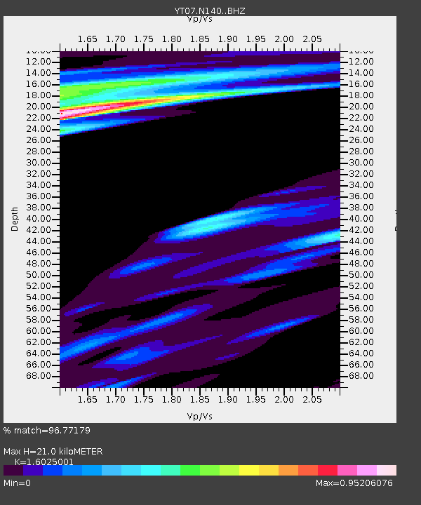
| Estimated Moho Depth: |
21.0 km |
| Estimated Crust Vp/Vs: |
1.60 |
| Assumed Crust Vp: |
6.261 km/s |
| Estimated Crust Vs: |
3.907 km/s |
| Estimated Crust Poisson's Ratio: |
0.18 |
|
| Radial Match: |
96.77179 % |
| Radial Bump: |
336 |
| Transverse Match: |
94.62959 % |
| Transverse Bump: |
400 |
| SOD ConfigId: |
7422571 |
| Insert Time: |
2019-04-18 17:27:54.688 +0000 |
| GWidth: |
2.5 |
| Max Bumps: |
400 |
| Tol: |
0.001 |
|

Signal To Noise
| Channel | StoN | STA | LTA |
| YT:N140: :BHZ:20150507T07:21:50.208025Z | 7.381872 | 3.2316032E-6 | 4.3777558E-7 |
| YT:N140: :BHN:20150507T07:21:50.208025Z | 1.5725496 | 7.0177714E-7 | 4.4626708E-7 |
| YT:N140: :BHE:20150507T07:21:50.208025Z | 1.2195208 | 7.847372E-7 | 6.4347995E-7 |
| Arrivals |
| Ps | 2.1 SECOND |
| PpPs | 8.5 SECOND |
| PsPs/PpSs | 11 SECOND |


