You are here: Home > Network List > ZJ12 - Transantarctic Mountains Northern Network Stations List
> Station DUBY Mt Kring, Antarctica > Earthquake Result Viewer
DUBY Mt Kring, Antarctica - Earthquake Result Viewer
| Earthquake location: |
Solomon Islands |
| Earthquake latitude/longitude: |
-7.3/154.5 |
| Earthquake time(UTC): |
2015/05/07 (127) 07:10:22 GMT |
| Earthquake Depth: |
22 km |
| Earthquake Magnitude: |
7.2 MWP, 7.2 MI |
| Earthquake Catalog/Contributor: |
NEIC PDE/NEIC COMCAT |
|
| Network: |
ZJ Transantarctic Mountains Northern Network |
| Station: |
DUBY Mt Kring, Antarctica |
| Lat/Lon: |
74.99 S/158.08 E |
| Elevation: |
1508 m |
|
| Distance: |
67.7 deg |
| Az: |
179.002 deg |
| Baz: |
356.2 deg |
| Ray Param: |
0.056766406 |
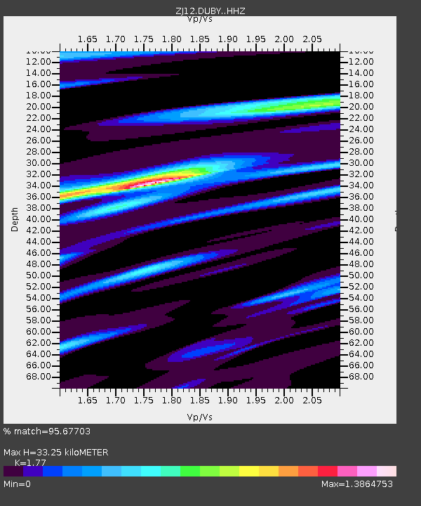
| Estimated Moho Depth: |
33.25 km |
| Estimated Crust Vp/Vs: |
1.77 |
| Assumed Crust Vp: |
6.182 km/s |
| Estimated Crust Vs: |
3.492 km/s |
| Estimated Crust Poisson's Ratio: |
0.27 |
|
| Radial Match: |
95.67703 % |
| Radial Bump: |
296 |
| Transverse Match: |
85.45064 % |
| Transverse Bump: |
400 |
| SOD ConfigId: |
7422571 |
| Insert Time: |
2019-04-18 17:28:08.763 +0000 |
| GWidth: |
2.5 |
| Max Bumps: |
400 |
| Tol: |
0.001 |
|

Signal To Noise
| Channel | StoN | STA | LTA |
| ZJ:DUBY: :HHZ:20150507T07:20:46.209001Z | 4.5749083 | 2.5137822E-6 | 5.494716E-7 |
| ZJ:DUBY: :HHN:20150507T07:20:46.209001Z | 1.0809623 | 8.490604E-7 | 7.854672E-7 |
| ZJ:DUBY: :HHE:20150507T07:20:46.209001Z | 1.616632 | 5.544867E-7 | 3.429888E-7 |
| Arrivals |
| Ps | 4.3 SECOND |
| PpPs | 14 SECOND |
| PsPs/PpSs | 19 SECOND |


