You are here: Home > Network List > IU - Global Seismograph Network (GSN - IRIS/USGS) Stations List
> Station HKT Hockley, Texas > Earthquake Result Viewer
HKT Hockley, Texas - Earthquake Result Viewer
| Earthquake location: |
Iceland |
| Earthquake latitude/longitude: |
64.0/-20.8 |
| Earthquake time(UTC): |
2000/06/21 (173) 00:51:46 GMT |
| Earthquake Depth: |
10 km |
| Earthquake Magnitude: |
6.1 MB, 6.6 MS, 6.5 MW, 6.4 MW |
| Earthquake Catalog/Contributor: |
WHDF/NEIC |
|
| Network: |
IU Global Seismograph Network (GSN - IRIS/USGS) |
| Station: |
HKT Hockley, Texas |
| Lat/Lon: |
29.96 N/95.84 W |
| Elevation: |
-413.0 m |
|
| Distance: |
57.0 deg |
| Az: |
271.274 deg |
| Baz: |
30.539 deg |
| Ray Param: |
0.063767485 |
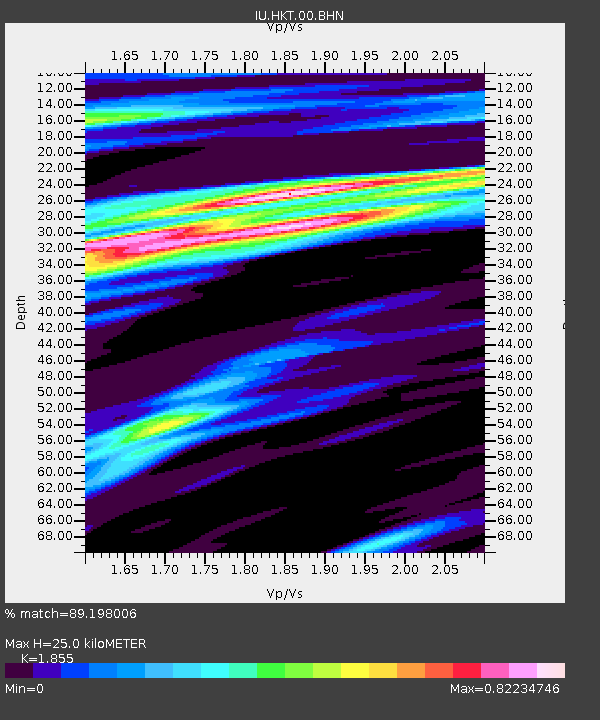
| Estimated Moho Depth: |
25.0 km |
| Estimated Crust Vp/Vs: |
1.86 |
| Assumed Crust Vp: |
5.581 km/s |
| Estimated Crust Vs: |
3.009 km/s |
| Estimated Crust Poisson's Ratio: |
0.30 |
|
| Radial Match: |
89.198006 % |
| Radial Bump: |
400 |
| Transverse Match: |
85.68622 % |
| Transverse Bump: |
382 |
| SOD ConfigId: |
3744 |
| Insert Time: |
2010-03-02 13:55:06.328 +0000 |
| GWidth: |
2.5 |
| Max Bumps: |
400 |
| Tol: |
0.001 |
|
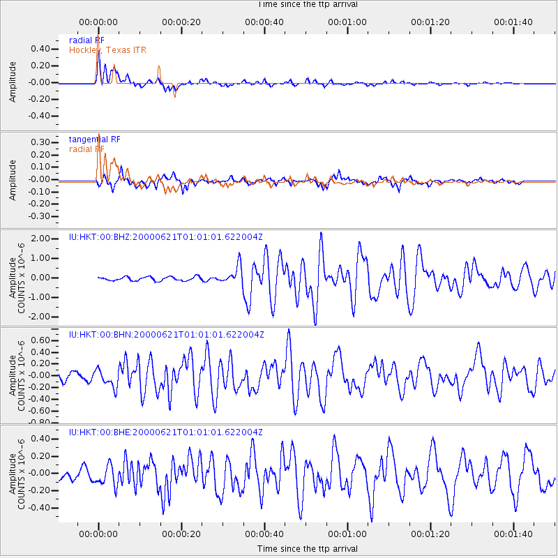
Signal To Noise
| Channel | StoN | STA | LTA |
| IU:HKT:00:BHN:20000621T01:01:01.622004Z | 2.2745366 | 1.5003552E-7 | 6.5963114E-8 |
| IU:HKT:00:BHE:20000621T01:01:01.622004Z | 1.9298701 | 1.2078925E-7 | 6.2589315E-8 |
| IU:HKT:00:BHZ:20000621T01:01:01.622004Z | 4.80112 | 4.7359666E-7 | 9.864296E-8 |
| Arrivals |
| Ps | 4.0 SECOND |
| PpPs | 12 SECOND |
| PsPs/PpSs | 16 SECOND |


