You are here: Home > Network List > AK - Alaska Regional Network Stations List
> Station CUT Chulitna, AK, USA > Earthquake Result Viewer
CUT Chulitna, AK, USA - Earthquake Result Viewer

| Earthquake location: |
Solomon Islands |
| Earthquake latitude/longitude: |
-7.4/154.8 |
| Earthquake time(UTC): |
2015/05/07 (127) 07:36:33 GMT |
| Earthquake Depth: |
31 km |
| Earthquake Magnitude: |
5.0 mb |
| Earthquake Catalog/Contributor: |
ISC/ISC |
|
| Network: |
AK Alaska Regional Network |
| Station: |
CUT Chulitna, AK, USA |
| Lat/Lon: |
62.41 N/150.26 W |
| Elevation: |
574 m |
|
| Distance: |
81.3 deg |
| Az: |
22.686 deg |
| Baz: |
235.223 deg |
| Ray Param: |
0.047646526 |
| Estimated Moho Depth: |
68.75 km |
| Estimated Crust Vp/Vs: |
1.78 |
| Assumed Crust Vp: |
6.438 km/s |
| Estimated Crust Vs: |
3.622 km/s |
| Estimated Crust Poisson's Ratio: |
0.27 |
|
| Radial Match: |
86.19363 % |
| Radial Bump: |
400 |
| Transverse Match: |
83.83293 % |
| Transverse Bump: |
400 |
| SOD ConfigId: |
7422571 |
| Insert Time: |
2019-04-18 17:28:38.033 +0000 |
| GWidth: |
2.5 |
| Max Bumps: |
400 |
| Tol: |
0.001 |
|
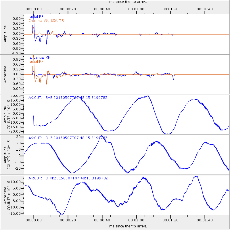
Signal To Noise
| Channel | StoN | STA | LTA |
| AK:CUT: :BHZ:20150507T07:48:15.319978Z | 3.083404 | 2.7788403E-5 | 9.012248E-6 |
| AK:CUT: :BHN:20150507T07:48:15.319978Z | 0.1409721 | 1.2806162E-6 | 9.084182E-6 |
| AK:CUT: :BHE:20150507T07:48:15.319978Z | 0.9816192 | 1.0651095E-5 | 1.08505365E-5 |
| Arrivals |
| Ps | 8.5 SECOND |
| PpPs | 29 SECOND |
| PsPs/PpSs | 37 SECOND |


