You are here: Home > Network List > IU - Global Seismograph Network (GSN - IRIS/USGS) Stations List
> Station HKT Hockley, Texas > Earthquake Result Viewer
HKT Hockley, Texas - Earthquake Result Viewer
| Earthquake location: |
Chile-Argentina Border Region |
| Earthquake latitude/longitude: |
-33.9/-70.1 |
| Earthquake time(UTC): |
2000/06/16 (168) 07:55:35 GMT |
| Earthquake Depth: |
120 km |
| Earthquake Magnitude: |
6.2 MB, 6.5 MW, 6.1 MD |
| Earthquake Catalog/Contributor: |
WHDF/NEIC |
|
| Network: |
IU Global Seismograph Network (GSN - IRIS/USGS) |
| Station: |
HKT Hockley, Texas |
| Lat/Lon: |
29.96 N/95.84 W |
| Elevation: |
-413.0 m |
|
| Distance: |
68.0 deg |
| Az: |
336.007 deg |
| Baz: |
157.056 deg |
| Ray Param: |
0.056272384 |
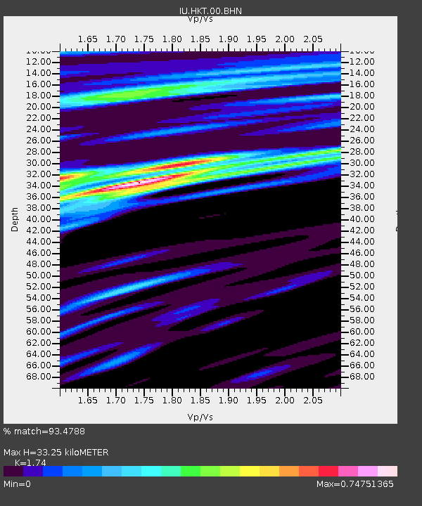
| Estimated Moho Depth: |
33.25 km |
| Estimated Crust Vp/Vs: |
1.74 |
| Assumed Crust Vp: |
5.581 km/s |
| Estimated Crust Vs: |
3.208 km/s |
| Estimated Crust Poisson's Ratio: |
0.25 |
|
| Radial Match: |
93.4788 % |
| Radial Bump: |
395 |
| Transverse Match: |
88.53129 % |
| Transverse Bump: |
400 |
| SOD ConfigId: |
3744 |
| Insert Time: |
2010-03-02 13:55:07.524 +0000 |
| GWidth: |
2.5 |
| Max Bumps: |
400 |
| Tol: |
0.001 |
|
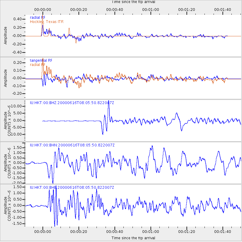
Signal To Noise
| Channel | StoN | STA | LTA |
| IU:HKT:00:BHN:20000616T08:05:50.822007Z | 7.2313404 | 5.8299196E-7 | 8.0620175E-8 |
| IU:HKT:00:BHE:20000616T08:05:50.822007Z | 6.153005 | 3.9786408E-7 | 6.466175E-8 |
| IU:HKT:00:BHZ:20000616T08:05:50.822007Z | 41.381245 | 3.4642987E-6 | 8.3716635E-8 |
| Arrivals |
| Ps | 4.5 SECOND |
| PpPs | 16 SECOND |
| PsPs/PpSs | 20 SECOND |


