You are here: Home > Network List > AK - Alaska Regional Network Stations List
> Station KTH Kantishna Hills > Earthquake Result Viewer
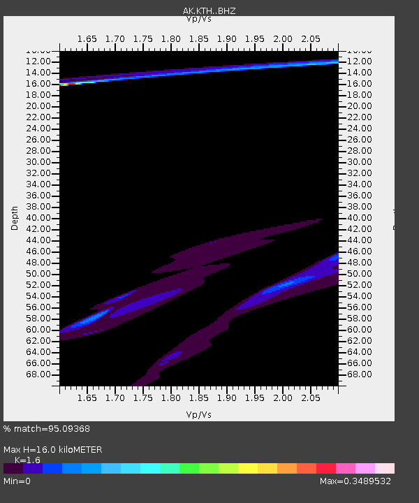
KTH Kantishna Hills - Earthquake Result Viewer
| Earthquake location: |
Solomon Islands |
| Earthquake latitude/longitude: |
-7.4/154.8 |
| Earthquake time(UTC): |
2015/05/07 (127) 07:36:33 GMT |
| Earthquake Depth: |
31 km |
| Earthquake Magnitude: |
5.0 mb |
| Earthquake Catalog/Contributor: |
ISC/ISC |
|
| Network: |
AK Alaska Regional Network |
| Station: |
KTH Kantishna Hills |
| Lat/Lon: |
63.55 N/150.92 W |
| Elevation: |
1172 m |
|
| Distance: |
81.7 deg |
| Az: |
21.559 deg |
| Baz: |
234.47 deg |
| Ray Param: |
0.047353495 |
| Estimated Moho Depth: |
16.0 km |
| Estimated Crust Vp/Vs: |
1.60 |
| Assumed Crust Vp: |
6.438 km/s |
| Estimated Crust Vs: |
4.024 km/s |
| Estimated Crust Poisson's Ratio: |
0.18 |
|
| Radial Match: |
95.09368 % |
| Radial Bump: |
326 |
| Transverse Match: |
86.74725 % |
| Transverse Bump: |
400 |
| SOD ConfigId: |
7422571 |
| Insert Time: |
2019-04-18 17:28:49.064 +0000 |
| GWidth: |
2.5 |
| Max Bumps: |
400 |
| Tol: |
0.001 |
|

Signal To Noise
| Channel | StoN | STA | LTA |
| AK:KTH: :BHZ:20150507T07:48:17.508027Z | 1.5628948 | 1.7204336E-5 | 1.1007994E-5 |
| AK:KTH: :BHN:20150507T07:48:17.508027Z | 2.5488799 | 1.1803367E-5 | 4.6308055E-6 |
| AK:KTH: :BHE:20150507T07:48:17.508027Z | 2.1970122 | 1.6252268E-5 | 7.397441E-6 |
| Arrivals |
| Ps | 1.5 SECOND |
| PpPs | 6.3 SECOND |
| PsPs/PpSs | 7.8 SECOND |


