You are here: Home > Network List > AK - Alaska Regional Network Stations List
> Station NEA2 Nenana, AK, USA > Earthquake Result Viewer
NEA2 Nenana, AK, USA - Earthquake Result Viewer
| Earthquake location: |
Solomon Islands |
| Earthquake latitude/longitude: |
-7.4/154.8 |
| Earthquake time(UTC): |
2015/05/07 (127) 07:36:33 GMT |
| Earthquake Depth: |
31 km |
| Earthquake Magnitude: |
5.0 mb |
| Earthquake Catalog/Contributor: |
ISC/ISC |
|
| Network: |
AK Alaska Regional Network |
| Station: |
NEA2 Nenana, AK, USA |
| Lat/Lon: |
64.59 N/149.07 W |
| Elevation: |
450 m |
|
| Distance: |
83.0 deg |
| Az: |
21.161 deg |
| Baz: |
236.081 deg |
| Ray Param: |
0.046474468 |
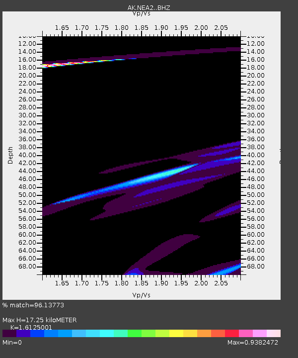
| Estimated Moho Depth: |
17.25 km |
| Estimated Crust Vp/Vs: |
1.61 |
| Assumed Crust Vp: |
6.566 km/s |
| Estimated Crust Vs: |
4.072 km/s |
| Estimated Crust Poisson's Ratio: |
0.19 |
|
| Radial Match: |
96.13773 % |
| Radial Bump: |
400 |
| Transverse Match: |
66.86716 % |
| Transverse Bump: |
400 |
| SOD ConfigId: |
7422571 |
| Insert Time: |
2019-04-18 17:28:53.689 +0000 |
| GWidth: |
2.5 |
| Max Bumps: |
400 |
| Tol: |
0.001 |
|

Signal To Noise
| Channel | StoN | STA | LTA |
| AK:NEA2: :BHZ:20150507T07:48:24.100007Z | 1.8499562 | 7.5869016E-6 | 4.101125E-6 |
| AK:NEA2: :BHN:20150507T07:48:24.100007Z | 0.22505245 | 1.0361156E-6 | 4.603885E-6 |
| AK:NEA2: :BHE:20150507T07:48:24.100007Z | 1.3849856 | 5.892903E-6 | 4.2548477E-6 |
| Arrivals |
| Ps | 1.7 SECOND |
| PpPs | 6.7 SECOND |
| PsPs/PpSs | 8.3 SECOND |


