You are here: Home > Network List > IU - Global Seismograph Network (GSN - IRIS/USGS) Stations List
> Station HKT Hockley, Texas > Earthquake Result Viewer
HKT Hockley, Texas - Earthquake Result Viewer
| Earthquake location: |
Tonga Islands |
| Earthquake latitude/longitude: |
-16.2/-173.8 |
| Earthquake time(UTC): |
2001/10/02 (275) 00:48:18 GMT |
| Earthquake Depth: |
107 km |
| Earthquake Magnitude: |
5.8 MB, 6.2 MW, 6.1 MW |
| Earthquake Catalog/Contributor: |
WHDF/NEIC |
|
| Network: |
IU Global Seismograph Network (GSN - IRIS/USGS) |
| Station: |
HKT Hockley, Texas |
| Lat/Lon: |
29.96 N/95.84 W |
| Elevation: |
-413.0 m |
|
| Distance: |
87.9 deg |
| Az: |
58.139 deg |
| Baz: |
250.123 deg |
| Ray Param: |
0.04273218 |
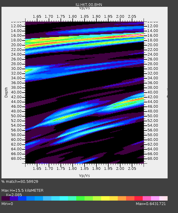
| Estimated Moho Depth: |
15.5 km |
| Estimated Crust Vp/Vs: |
2.09 |
| Assumed Crust Vp: |
5.581 km/s |
| Estimated Crust Vs: |
2.677 km/s |
| Estimated Crust Poisson's Ratio: |
0.35 |
|
| Radial Match: |
80.59929 % |
| Radial Bump: |
373 |
| Transverse Match: |
61.079266 % |
| Transverse Bump: |
400 |
| SOD ConfigId: |
20082 |
| Insert Time: |
2010-03-02 13:55:48.053 +0000 |
| GWidth: |
2.5 |
| Max Bumps: |
400 |
| Tol: |
0.001 |
|
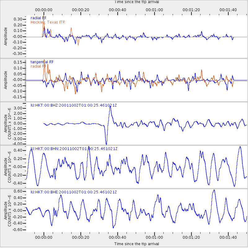
Signal To Noise
| Channel | StoN | STA | LTA |
| IU:HKT:00:BHN:20011002T01:00:25.461021Z | 1.1537546 | 2.2257122E-7 | 1.9291035E-7 |
| IU:HKT:00:BHE:20011002T01:00:25.461021Z | 2.0371423 | 2.126482E-7 | 1.04385535E-7 |
| IU:HKT:00:BHZ:20011002T01:00:25.461021Z | 11.678039 | 1.600778E-6 | 1.3707593E-7 |
| Arrivals |
| Ps | 3.1 SECOND |
| PpPs | 8.4 SECOND |
| PsPs/PpSs | 12 SECOND |


