You are here: Home > Network List > IU - Global Seismograph Network (GSN - IRIS/USGS) Stations List
> Station HKT Hockley, Texas > Earthquake Result Viewer
HKT Hockley, Texas - Earthquake Result Viewer

| Earthquake location: |
Colombia |
| Earthquake latitude/longitude: |
3.9/-76.0 |
| Earthquake time(UTC): |
2001/09/22 (265) 03:23:38 GMT |
| Earthquake Depth: |
179 km |
| Earthquake Magnitude: |
6.0 MB, 6.0 MW, 6.0 MW |
| Earthquake Catalog/Contributor: |
WHDF/NEIC |
|
| Network: |
IU Global Seismograph Network (GSN - IRIS/USGS) |
| Station: |
HKT Hockley, Texas |
| Lat/Lon: |
29.96 N/95.84 W |
| Elevation: |
-413.0 m |
|
| Distance: |
32.0 deg |
| Az: |
326.225 deg |
| Baz: |
140.27 deg |
| Ray Param: |
0.07828251 |
| Estimated Moho Depth: |
27.5 km |
| Estimated Crust Vp/Vs: |
1.80 |
| Assumed Crust Vp: |
5.581 km/s |
| Estimated Crust Vs: |
3.101 km/s |
| Estimated Crust Poisson's Ratio: |
0.28 |
|
| Radial Match: |
87.82085 % |
| Radial Bump: |
394 |
| Transverse Match: |
37.96947 % |
| Transverse Bump: |
400 |
| SOD ConfigId: |
20082 |
| Insert Time: |
2010-03-02 13:55:51.132 +0000 |
| GWidth: |
2.5 |
| Max Bumps: |
400 |
| Tol: |
0.001 |
|
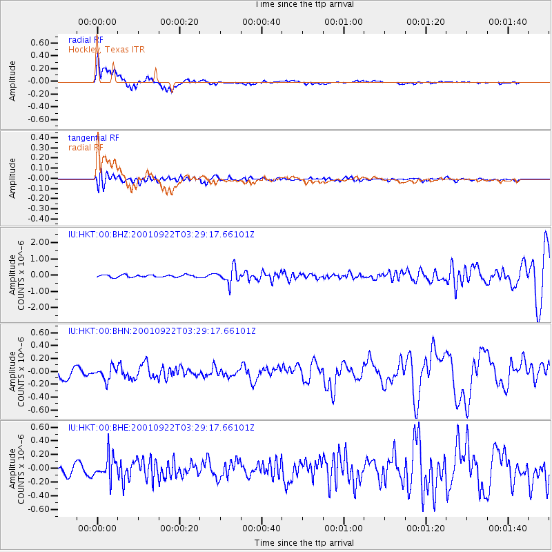
Signal To Noise
| Channel | StoN | STA | LTA |
| IU:HKT:00:BHN:20010922T03:29:17.66101Z | 1.2772518 | 1.0165787E-7 | 7.9591096E-8 |
| IU:HKT:00:BHE:20010922T03:29:17.66101Z | 2.0262113 | 1.6757062E-7 | 8.2701455E-8 |
| IU:HKT:00:BHZ:20010922T03:29:17.66101Z | 6.866523 | 4.8851797E-7 | 7.114488E-8 |
| Arrivals |
| Ps | 4.2 SECOND |
| PpPs | 13 SECOND |
| PsPs/PpSs | 17 SECOND |


