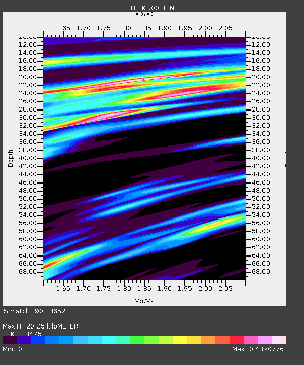
HKT Hockley, Texas - Earthquake Result Viewer
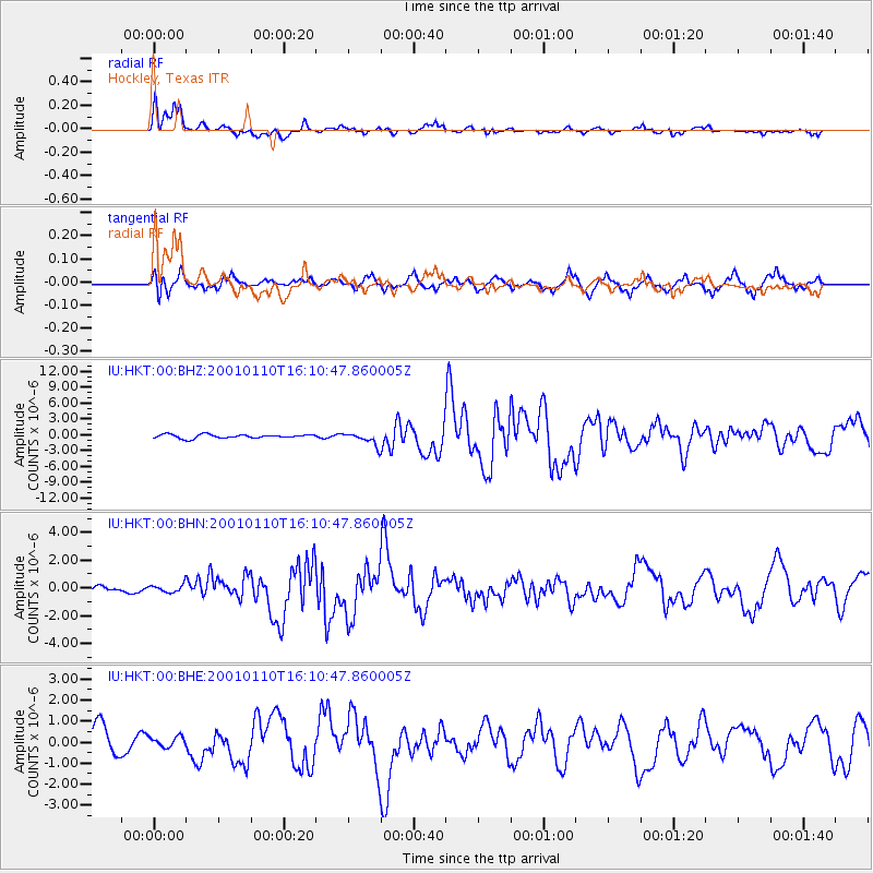
Earthquake location: Kodiak Island Region, Alaska
Earthquake latitude/longitude: 57.1/-153.2
Earthquake time(UTC): 2001/01/10 (010) 16:02:44 GMT
Earthquake Depth: 33 km
Earthquake Magnitude: 6.2 MB, 6.8 MS, 7.1 MW, 6.8 ML
Earthquake Catalog/Contributor: WHDF/NEIC
Network: IU Global Seismograph Network (GSN - IRIS/USGS)
Station: HKT Hockley, Texas
Lat/Lon: 29.96 N/95.84 W
Elevation: -413.0 m
Distance: 47.8 deg
Az: 99.372 deg
Baz: 321.621 deg
Ray Param: 0.06970137
Estimated Moho Depth: 20.25 km
Estimated Crust Vp/Vs: 1.85
Assumed Crust Vp: 5.581 km/s
Estimated Crust Vs: 3.021 km/s
Estimated Crust Poisson's Ratio: 0.29
Radial Match: 90.13652 %
Radial Bump: 359
Transverse Match: 65.70237 %
Transverse Bump: 400
SOD ConfigId: 3744
Insert Time: 2010-03-02 13:55:59.962 +0000
GWidth: 2.5
Max Bumps: 400
Tol: 0.001

Signal To Noise

ChannelStoNSTALTA
IU:HKT:00:BHN:20010110T16:10:47.860005Z1.09811572.9693578E-72.7040483E-7
IU:HKT:00:BHE:20010110T16:10:47.860005Z0.361655832.6760856E-77.399536E-7
IU:HKT:00:BHZ:20010110T16:10:47.860005Z3.405871.1891599E-63.491501E-7
Arrivals
Ps3.2 SECOND
PpPs9.9 SECOND
PsPs/PpSs13 SECOND