You are here: Home > Network List > IU - Global Seismograph Network (GSN - IRIS/USGS) Stations List
> Station HKT Hockley, Texas > Earthquake Result Viewer
HKT Hockley, Texas - Earthquake Result Viewer
| Earthquake location: |
Kuril Islands |
| Earthquake latitude/longitude: |
44.3/148.4 |
| Earthquake time(UTC): |
2001/05/25 (145) 00:40:50 GMT |
| Earthquake Depth: |
33 km |
| Earthquake Magnitude: |
6.1 MB, 6.7 MS, 6.7 MW, 6.6 MW |
| Earthquake Catalog/Contributor: |
WHDF/NEIC |
|
| Network: |
IU Global Seismograph Network (GSN - IRIS/USGS) |
| Station: |
HKT Hockley, Texas |
| Lat/Lon: |
29.96 N/95.84 W |
| Elevation: |
-413.0 m |
|
| Distance: |
85.7 deg |
| Az: |
51.6 deg |
| Baz: |
319.55 deg |
| Ray Param: |
0.04451859 |
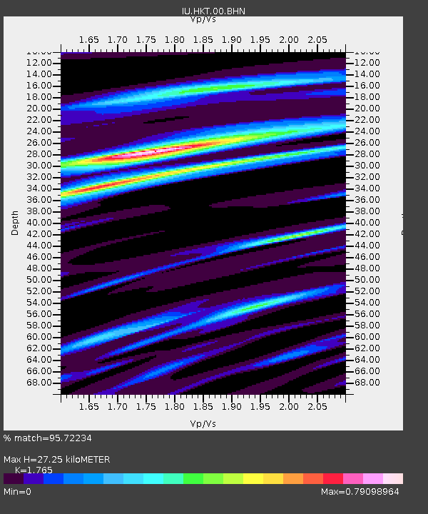
| Estimated Moho Depth: |
27.25 km |
| Estimated Crust Vp/Vs: |
1.76 |
| Assumed Crust Vp: |
5.581 km/s |
| Estimated Crust Vs: |
3.162 km/s |
| Estimated Crust Poisson's Ratio: |
0.26 |
|
| Radial Match: |
95.72234 % |
| Radial Bump: |
371 |
| Transverse Match: |
89.967926 % |
| Transverse Bump: |
400 |
| SOD ConfigId: |
4714 |
| Insert Time: |
2010-03-02 13:56:09.144 +0000 |
| GWidth: |
2.5 |
| Max Bumps: |
400 |
| Tol: |
0.001 |
|
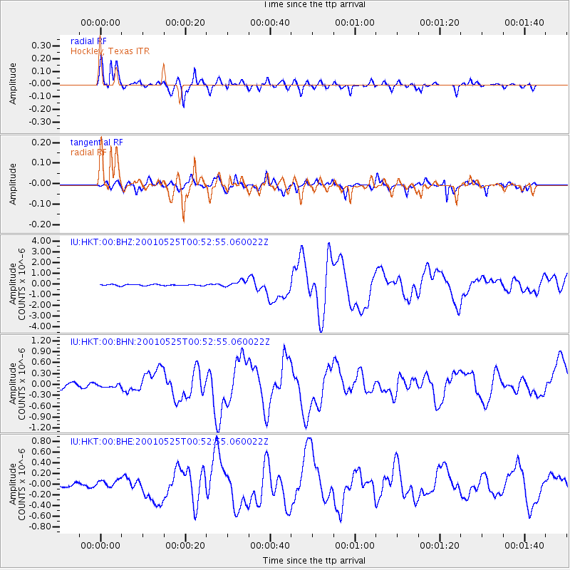
Signal To Noise
| Channel | StoN | STA | LTA |
| IU:HKT:00:BHN:20010525T00:52:55.060022Z | 0.7508475 | 5.0653895E-8 | 6.7462295E-8 |
| IU:HKT:00:BHE:20010525T00:52:55.060022Z | 1.8850898 | 8.366106E-8 | 4.438041E-8 |
| IU:HKT:00:BHZ:20010525T00:52:55.060022Z | 5.659388 | 3.1751628E-7 | 5.6104348E-8 |
| Arrivals |
| Ps | 3.8 SECOND |
| PpPs | 13 SECOND |
| PsPs/PpSs | 17 SECOND |


