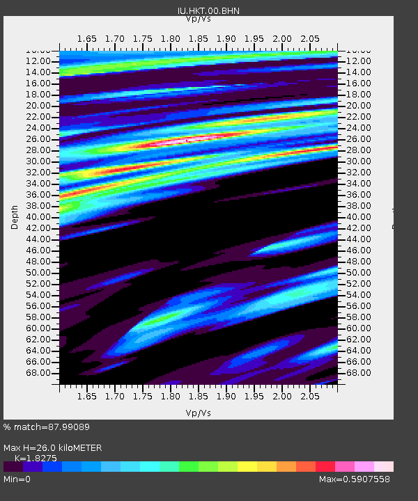
HKT Hockley, Texas - Earthquake Result Viewer
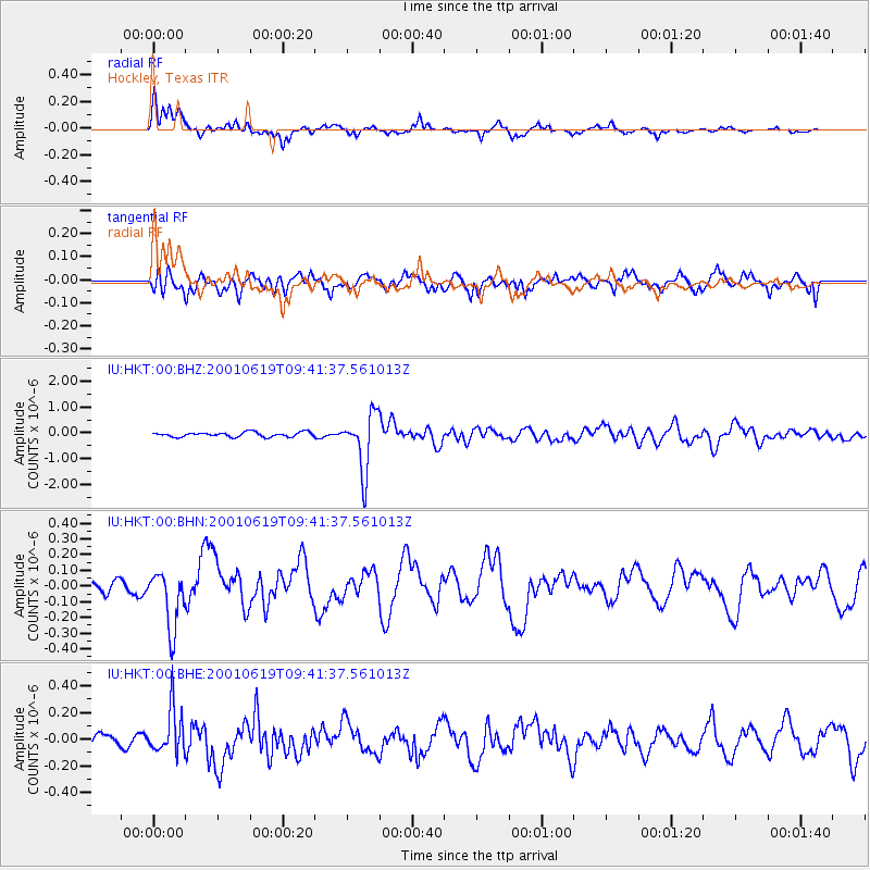
Earthquake location: Chile-Bolivia Border Region
Earthquake latitude/longitude: -22.7/-67.9
Earthquake time(UTC): 2001/06/19 (170) 09:32:24 GMT
Earthquake Depth: 147 km
Earthquake Magnitude: 5.5 MB, 5.2 MS, 6.1 MW, 5.9 MW
Earthquake Catalog/Contributor: WHDF/NEIC
Network: IU Global Seismograph Network (GSN - IRIS/USGS)
Station: HKT Hockley, Texas
Lat/Lon: 29.96 N/95.84 W
Elevation: -413.0 m
Distance: 58.9 deg
Az: 331.625 deg
Baz: 149.631 deg
Ray Param: 0.062090166
Estimated Moho Depth: 26.0 km
Estimated Crust Vp/Vs: 1.83
Assumed Crust Vp: 5.581 km/s
Estimated Crust Vs: 3.054 km/s
Estimated Crust Poisson's Ratio: 0.29
Radial Match: 87.99089 %
Radial Bump: 310
Transverse Match: 77.78656 %
Transverse Bump: 400
SOD ConfigId: 4714
Insert Time: 2010-03-02 13:56:15.208 +0000
GWidth: 2.5
Max Bumps: 400
Tol: 0.001

Signal To Noise

ChannelStoNSTALTA
IU:HKT:00:BHN:20010619T09:41:37.561013Z3.92055441.8481722E-74.7140585E-8
IU:HKT:00:BHE:20010619T09:41:37.561013Z2.75539681.6754193E-76.080501E-8
IU:HKT:00:BHZ:20010619T09:41:37.561013Z12.4027081.1158278E-68.996646E-8
Arrivals
Ps4.0 SECOND
PpPs13 SECOND
PsPs/PpSs17 SECOND