You are here: Home > Network List > TA - USArray Transportable Network (new EarthScope stations) Stations List
> Station I23K Minto, Yukon-Koyukuk, AK, USA > Earthquake Result Viewer
I23K Minto, Yukon-Koyukuk, AK, USA - Earthquake Result Viewer
| Earthquake location: |
Solomon Islands |
| Earthquake latitude/longitude: |
-7.4/154.8 |
| Earthquake time(UTC): |
2015/05/07 (127) 07:36:33 GMT |
| Earthquake Depth: |
31 km |
| Earthquake Magnitude: |
5.0 mb |
| Earthquake Catalog/Contributor: |
ISC/ISC |
|
| Network: |
TA USArray Transportable Network (new EarthScope stations) |
| Station: |
I23K Minto, Yukon-Koyukuk, AK, USA |
| Lat/Lon: |
65.15 N/149.36 W |
| Elevation: |
149 m |
|
| Distance: |
83.2 deg |
| Az: |
20.626 deg |
| Baz: |
235.753 deg |
| Ray Param: |
0.046328533 |
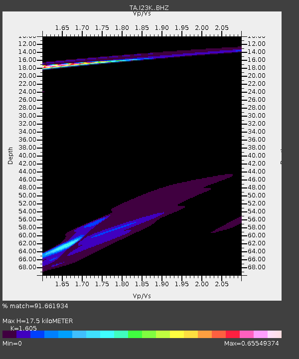
| Estimated Moho Depth: |
17.5 km |
| Estimated Crust Vp/Vs: |
1.61 |
| Assumed Crust Vp: |
6.566 km/s |
| Estimated Crust Vs: |
4.091 km/s |
| Estimated Crust Poisson's Ratio: |
0.18 |
|
| Radial Match: |
91.661934 % |
| Radial Bump: |
373 |
| Transverse Match: |
21.24462 % |
| Transverse Bump: |
400 |
| SOD ConfigId: |
7422571 |
| Insert Time: |
2019-04-18 17:32:13.451 +0000 |
| GWidth: |
2.5 |
| Max Bumps: |
400 |
| Tol: |
0.001 |
|
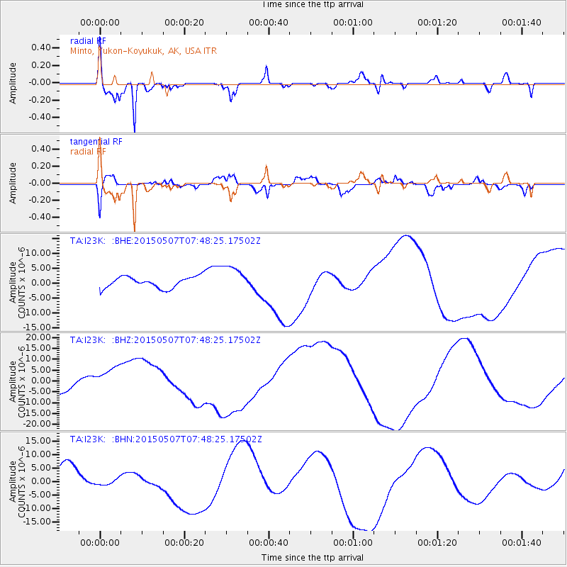
Signal To Noise
| Channel | StoN | STA | LTA |
| TA:I23K: :BHZ:20150507T07:48:25.17502Z | 3.4974494 | 7.3425554E-6 | 2.099403E-6 |
| TA:I23K: :BHN:20150507T07:48:25.17502Z | 0.27724722 | 1.0890528E-6 | 3.928093E-6 |
| TA:I23K: :BHE:20150507T07:48:25.17502Z | 2.2822006 | 4.3677333E-6 | 1.9138254E-6 |
| Arrivals |
| Ps | 1.7 SECOND |
| PpPs | 6.7 SECOND |
| PsPs/PpSs | 8.4 SECOND |


