You are here: Home > Network List > IU - Global Seismograph Network (GSN - IRIS/USGS) Stations List
> Station HKT Hockley, Texas > Earthquake Result Viewer
HKT Hockley, Texas - Earthquake Result Viewer
| Earthquake location: |
Near Coast Of Peru |
| Earthquake latitude/longitude: |
-16.3/-73.6 |
| Earthquake time(UTC): |
2001/06/23 (174) 20:33:14 GMT |
| Earthquake Depth: |
33 km |
| Earthquake Magnitude: |
6.7 MB, 8.2 MS, 8.4 MW, 7.8 ME |
| Earthquake Catalog/Contributor: |
WHDF/NEIC |
|
| Network: |
IU Global Seismograph Network (GSN - IRIS/USGS) |
| Station: |
HKT Hockley, Texas |
| Lat/Lon: |
29.96 N/95.84 W |
| Elevation: |
-413.0 m |
|
| Distance: |
50.7 deg |
| Az: |
334.932 deg |
| Baz: |
152.035 deg |
| Ray Param: |
0.067816585 |
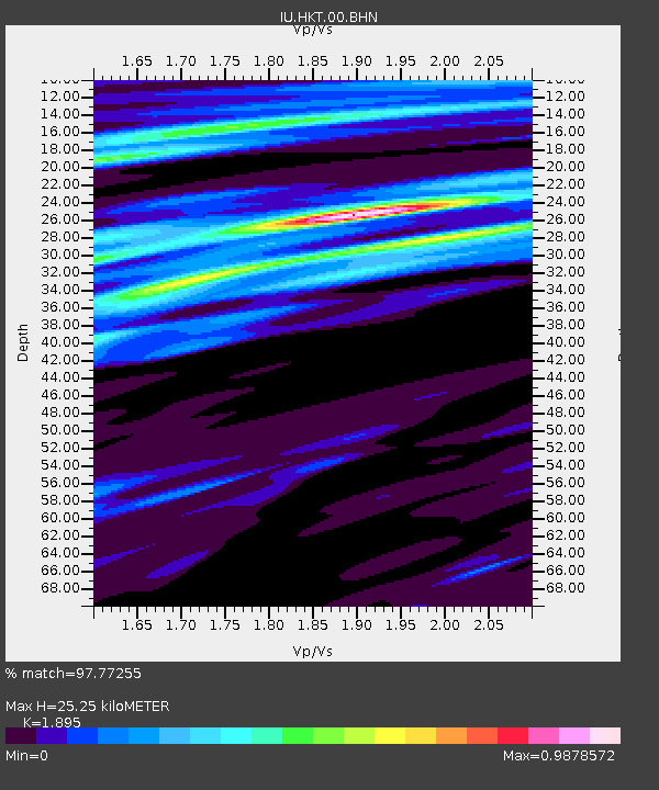
| Estimated Moho Depth: |
25.25 km |
| Estimated Crust Vp/Vs: |
1.89 |
| Assumed Crust Vp: |
5.581 km/s |
| Estimated Crust Vs: |
2.945 km/s |
| Estimated Crust Poisson's Ratio: |
0.31 |
|
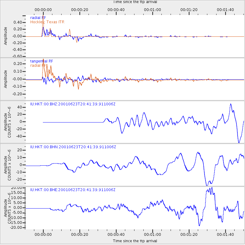
| Radial Match: |
97.77255 % |
| Radial Bump: |
231 |
| Transverse Match: |
83.63832 % |
| Transverse Bump: |
400 |
| SOD ConfigId: |
4714 |
| Insert Time: |
2010-03-02 13:56:17.969 +0000 |
| GWidth: |
2.5 |
| Max Bumps: |
400 |
| Tol: |
0.001 |
|
Signal To Noise
| Channel | StoN | STA | LTA |
| IU:HKT:00:BHN:20010623T20:41:39.911006Z | 6.938851 | 8.1681776E-7 | 1.1771658E-7 |
| IU:HKT:00:BHE:20010623T20:41:39.911006Z | 7.7441916 | 4.5650722E-7 | 5.8948338E-8 |
| IU:HKT:00:BHZ:20010623T20:41:39.911006Z | 45.403572 | 4.150439E-6 | 9.1412176E-8 |
| Arrivals |
| Ps | 4.2 SECOND |
| PpPs | 13 SECOND |
| PsPs/PpSs | 17 SECOND |


