You are here: Home > Network List > TA - USArray Transportable Network (new EarthScope stations) Stations List
> Station M24K Tolsona, Glennallen, AK, USA > Earthquake Result Viewer
M24K Tolsona, Glennallen, AK, USA - Earthquake Result Viewer
| Earthquake location: |
Solomon Islands |
| Earthquake latitude/longitude: |
-7.4/154.8 |
| Earthquake time(UTC): |
2015/05/07 (127) 07:36:33 GMT |
| Earthquake Depth: |
31 km |
| Earthquake Magnitude: |
5.0 mb |
| Earthquake Catalog/Contributor: |
ISC/ISC |
|
| Network: |
TA USArray Transportable Network (new EarthScope stations) |
| Station: |
M24K Tolsona, Glennallen, AK, USA |
| Lat/Lon: |
62.11 N/146.18 W |
| Elevation: |
908 m |
|
| Distance: |
82.7 deg |
| Az: |
23.989 deg |
| Baz: |
239.016 deg |
| Ray Param: |
0.046639483 |
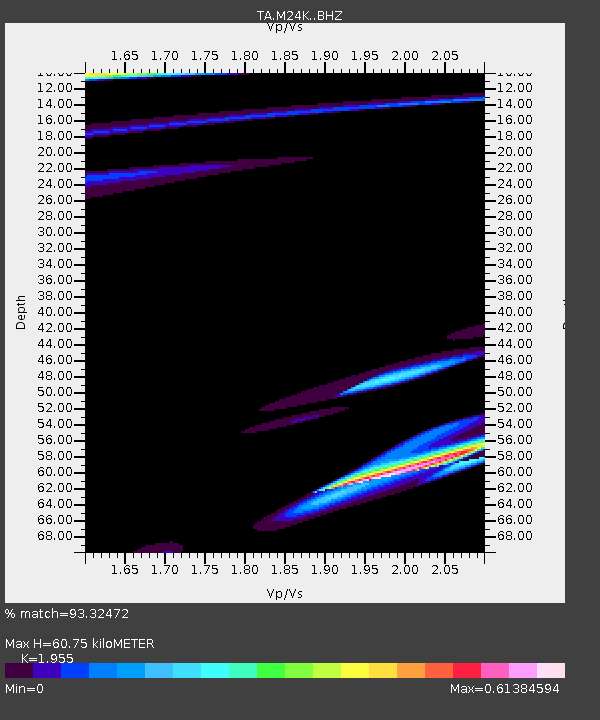
| Estimated Moho Depth: |
60.75 km |
| Estimated Crust Vp/Vs: |
1.96 |
| Assumed Crust Vp: |
6.566 km/s |
| Estimated Crust Vs: |
3.359 km/s |
| Estimated Crust Poisson's Ratio: |
0.32 |
|
| Radial Match: |
93.32472 % |
| Radial Bump: |
366 |
| Transverse Match: |
43.71525 % |
| Transverse Bump: |
400 |
| SOD ConfigId: |
7422571 |
| Insert Time: |
2019-04-18 17:32:16.514 +0000 |
| GWidth: |
2.5 |
| Max Bumps: |
400 |
| Tol: |
0.001 |
|
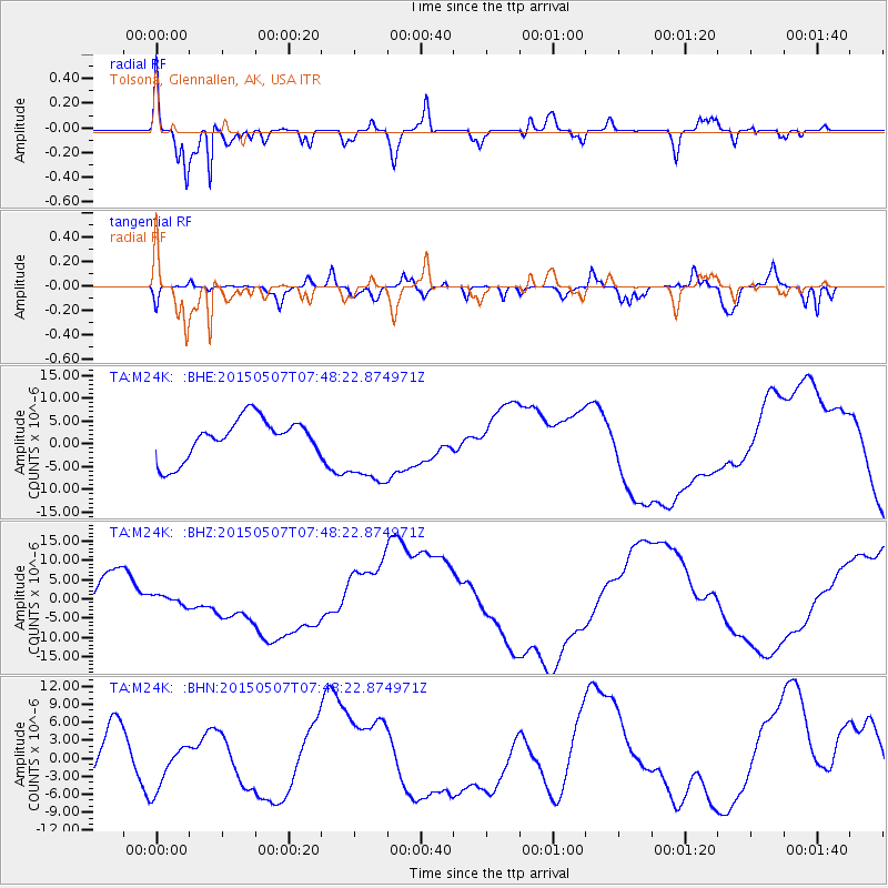
Signal To Noise
| Channel | StoN | STA | LTA |
| TA:M24K: :BHZ:20150507T07:48:22.874971Z | 0.40986428 | 1.4210771E-6 | 3.4671893E-6 |
| TA:M24K: :BHN:20150507T07:48:22.874971Z | 1.1798222 | 3.7718653E-6 | 3.1969776E-6 |
| TA:M24K: :BHE:20150507T07:48:22.874971Z | 1.9805951 | 8.619165E-6 | 4.3518057E-6 |
| Arrivals |
| Ps | 9.1 SECOND |
| PpPs | 27 SECOND |
| PsPs/PpSs | 36 SECOND |


