You are here: Home > Network List > IU - Global Seismograph Network (GSN - IRIS/USGS) Stations List
> Station HKT Hockley, Texas > Earthquake Result Viewer
HKT Hockley, Texas - Earthquake Result Viewer
| Earthquake location: |
Fiji Islands Region |
| Earthquake latitude/longitude: |
-21.7/-176.7 |
| Earthquake time(UTC): |
2001/07/04 (185) 07:06:31 GMT |
| Earthquake Depth: |
185 km |
| Earthquake Magnitude: |
5.9 MB, 5.8 MS, 6.5 MW, 6.5 MW |
| Earthquake Catalog/Contributor: |
WHDF/NEIC |
|
| Network: |
IU Global Seismograph Network (GSN - IRIS/USGS) |
| Station: |
HKT Hockley, Texas |
| Lat/Lon: |
29.96 N/95.84 W |
| Elevation: |
-413.0 m |
|
| Distance: |
93.1 deg |
| Az: |
59.103 deg |
| Baz: |
246.84 deg |
| Ray Param: |
0.041210074 |
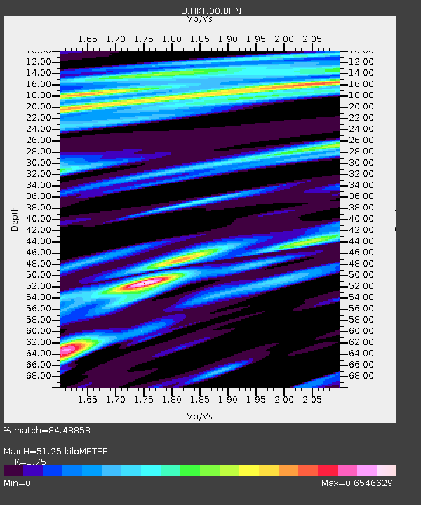
| Estimated Moho Depth: |
51.25 km |
| Estimated Crust Vp/Vs: |
1.75 |
| Assumed Crust Vp: |
5.581 km/s |
| Estimated Crust Vs: |
3.189 km/s |
| Estimated Crust Poisson's Ratio: |
0.26 |
|
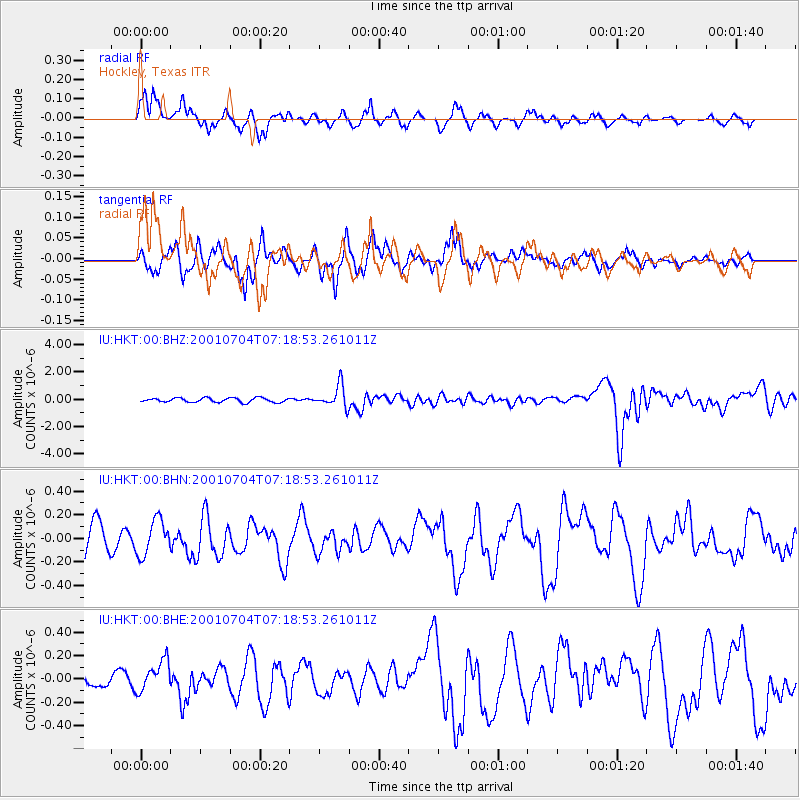
| Radial Match: |
84.48858 % |
| Radial Bump: |
386 |
| Transverse Match: |
72.77053 % |
| Transverse Bump: |
384 |
| SOD ConfigId: |
4714 |
| Insert Time: |
2010-03-02 13:56:24.443 +0000 |
| GWidth: |
2.5 |
| Max Bumps: |
400 |
| Tol: |
0.001 |
|
Signal To Noise
| Channel | StoN | STA | LTA |
| IU:HKT:00:BHN:20010704T07:18:53.261011Z | 1.1790999 | 1.5172557E-7 | 1.2867915E-7 |
| IU:HKT:00:BHE:20010704T07:18:53.261011Z | 1.3217896 | 1.358245E-7 | 1.0275803E-7 |
| IU:HKT:00:BHZ:20010704T07:18:53.261011Z | 4.9776673 | 8.0141405E-7 | 1.6100192E-7 |
| Arrivals |
| Ps | 7.0 SECOND |
| PpPs | 25 SECOND |
| PsPs/PpSs | 32 SECOND |


