You are here: Home > Network List > IU - Global Seismograph Network (GSN - IRIS/USGS) Stations List
> Station HKT Hockley, Texas > Earthquake Result Viewer
HKT Hockley, Texas - Earthquake Result Viewer
| Earthquake location: |
Central Bolivia |
| Earthquake latitude/longitude: |
-17.0/-65.7 |
| Earthquake time(UTC): |
2001/07/04 (185) 12:09:03 GMT |
| Earthquake Depth: |
33 km |
| Earthquake Magnitude: |
5.6 MB, 5.9 MS, 6.1 MW, 6.1 MW |
| Earthquake Catalog/Contributor: |
WHDF/NEIC |
|
| Network: |
IU Global Seismograph Network (GSN - IRIS/USGS) |
| Station: |
HKT Hockley, Texas |
| Lat/Lon: |
29.96 N/95.84 W |
| Elevation: |
-413.0 m |
|
| Distance: |
55.0 deg |
| Az: |
327.872 deg |
| Baz: |
144.099 deg |
| Ray Param: |
0.065031216 |
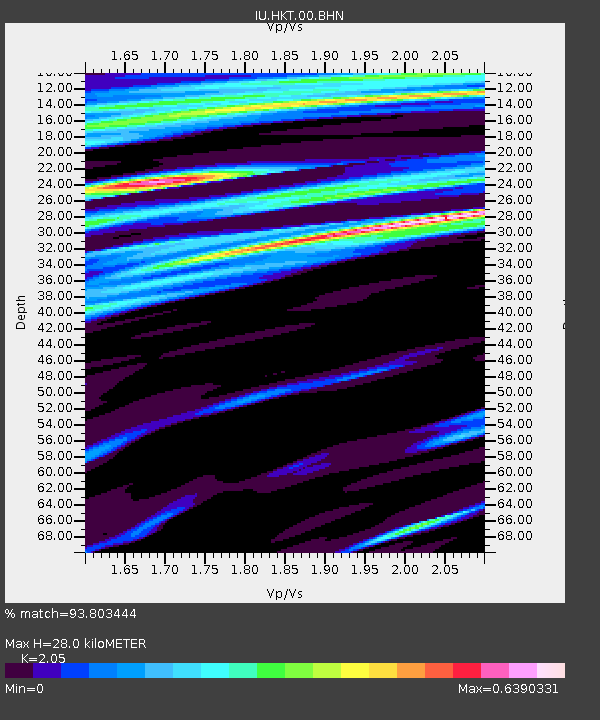
| Estimated Moho Depth: |
28.0 km |
| Estimated Crust Vp/Vs: |
2.05 |
| Assumed Crust Vp: |
5.581 km/s |
| Estimated Crust Vs: |
2.723 km/s |
| Estimated Crust Poisson's Ratio: |
0.34 |
|
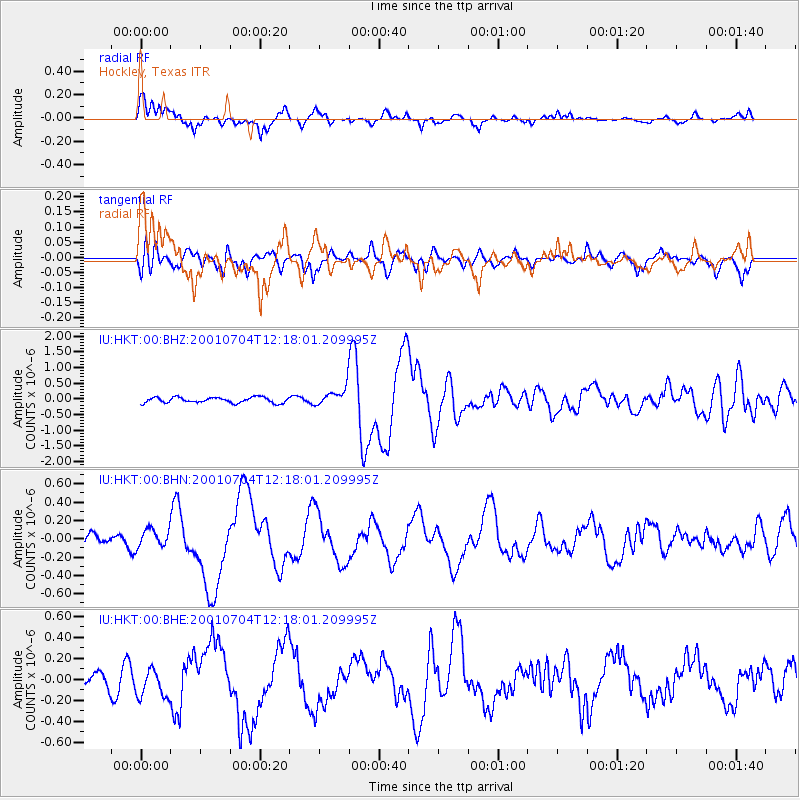
| Radial Match: |
93.803444 % |
| Radial Bump: |
400 |
| Transverse Match: |
74.441315 % |
| Transverse Bump: |
400 |
| SOD ConfigId: |
4714 |
| Insert Time: |
2010-03-02 13:56:26.839 +0000 |
| GWidth: |
2.5 |
| Max Bumps: |
400 |
| Tol: |
0.001 |
|
Signal To Noise
| Channel | StoN | STA | LTA |
| IU:HKT:00:BHN:20010704T12:18:01.209995Z | 1.6647849 | 9.8949705E-8 | 5.9436932E-8 |
| IU:HKT:00:BHE:20010704T12:18:01.209995Z | 2.825229 | 1.368408E-7 | 4.8435297E-8 |
| IU:HKT:00:BHZ:20010704T12:18:01.209995Z | 3.163105 | 2.8248667E-7 | 8.930676E-8 |
| Arrivals |
| Ps | 5.4 SECOND |
| PpPs | 15 SECOND |
| PsPs/PpSs | 20 SECOND |


