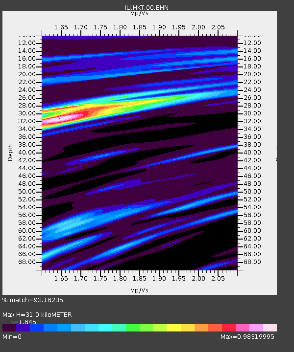
HKT Hockley, Texas - Earthquake Result Viewer
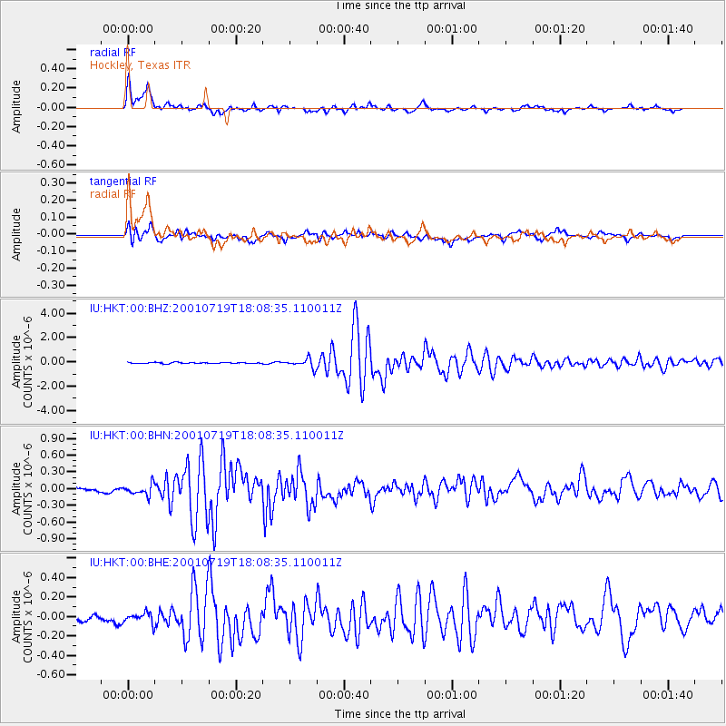
Earthquake location: Kodiak Island Region, Alaska
Earthquake latitude/longitude: 57.2/-151.0
Earthquake time(UTC): 2001/07/19 (200) 18:00:40 GMT
Earthquake Depth: 33 km
Earthquake Magnitude: 5.9 MB, 5.4 MS, 5.9 MW, 5.9 ML
Earthquake Catalog/Contributor: WHDF/NEIC
Network: IU Global Seismograph Network (GSN - IRIS/USGS)
Station: HKT Hockley, Texas
Lat/Lon: 29.96 N/95.84 W
Elevation: -413.0 m
Distance: 46.7 deg
Az: 101.509 deg
Baz: 322.082 deg
Ray Param: 0.07044609
Estimated Moho Depth: 31.0 km
Estimated Crust Vp/Vs: 1.64
Assumed Crust Vp: 5.581 km/s
Estimated Crust Vs: 3.393 km/s
Estimated Crust Poisson's Ratio: 0.21
Radial Match: 93.16235 %
Radial Bump: 400
Transverse Match: 71.51761 %
Transverse Bump: 400
SOD ConfigId: 3753
Insert Time: 2010-03-02 13:56:42.693 +0000
GWidth: 2.5
Max Bumps: 400
Tol: 0.001

Signal To Noise

ChannelStoNSTALTA
IU:HKT:00:BHN:20010719T18:08:35.110011Z1.41393771.1935818E-78.441545E-8
IU:HKT:00:BHE:20010719T18:08:35.110011Z1.0216896.417814E-86.281572E-8
IU:HKT:00:BHZ:20010719T18:08:35.110011Z8.4763863.8743866E-74.5708003E-8
Arrivals
Ps3.8 SECOND
PpPs14 SECOND
PsPs/PpSs18 SECOND