You are here: Home > Network List > TA - USArray Transportable Network (new EarthScope stations) Stations List
> Station R11A Troy Canyon, Currant, NV, USA > Earthquake Result Viewer
R11A Troy Canyon, Currant, NV, USA - Earthquake Result Viewer
*The percent match for this event was below the threshold and hence no stack was calculated.
| Earthquake location: |
Greece |
| Earthquake latitude/longitude: |
38.9/21.2 |
| Earthquake time(UTC): |
2014/10/24 (297) 23:43:15 GMT |
| Earthquake Depth: |
10 km |
| Earthquake Magnitude: |
5.5 MB, 5.2 MWR |
| Earthquake Catalog/Contributor: |
NEIC PDE/NEIC COMCAT |
|
| Network: |
TA USArray Transportable Network (new EarthScope stations) |
| Station: |
R11A Troy Canyon, Currant, NV, USA |
| Lat/Lon: |
38.35 N/115.59 W |
| Elevation: |
1756 m |
|
| Distance: |
93.4 deg |
| Az: |
327.327 deg |
| Baz: |
32.379 deg |
| Ray Param: |
$rayparam |
*The percent match for this event was below the threshold and hence was not used in the summary stack. |
|
| Radial Match: |
67.31145 % |
| Radial Bump: |
400 |
| Transverse Match: |
45.578377 % |
| Transverse Bump: |
400 |
| SOD ConfigId: |
811962 |
| Insert Time: |
2014-11-08 00:17:42.088 +0000 |
| GWidth: |
2.5 |
| Max Bumps: |
400 |
| Tol: |
0.001 |
|
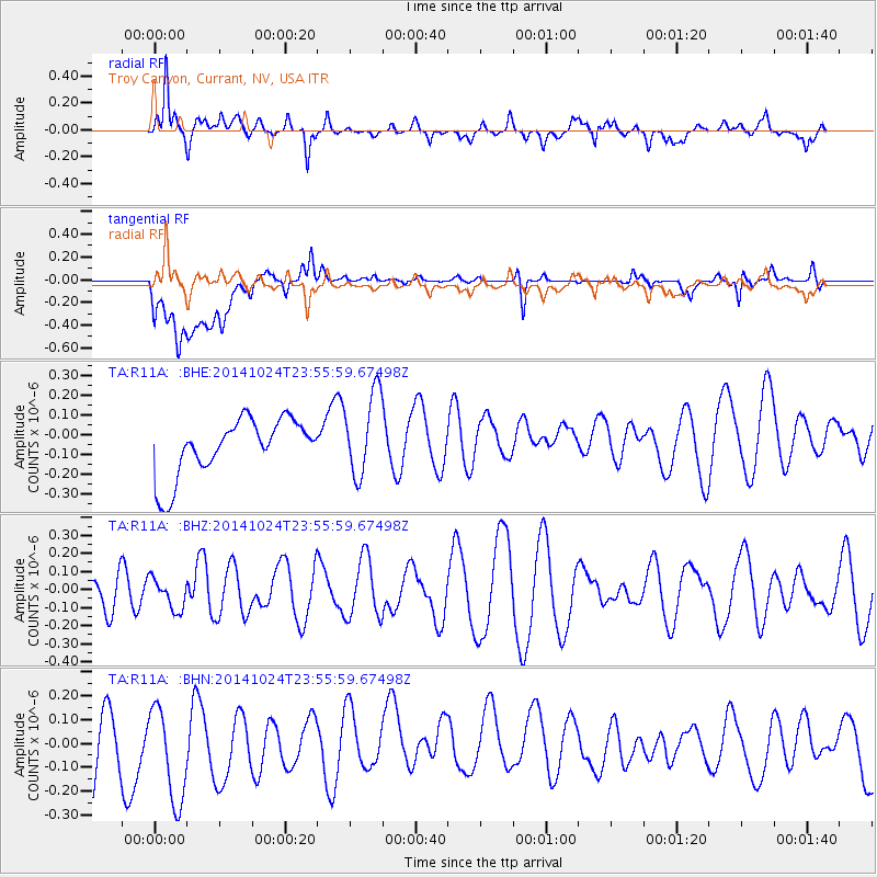
Signal To Noise
| Channel | StoN | STA | LTA |
| TA:R11A: :BHZ:20141024T23:55:59.67498Z | 0.72972584 | 8.45546E-8 | 1.1587174E-7 |
| TA:R11A: :BHN:20141024T23:55:59.67498Z | 1.5477219 | 2.2014123E-7 | 1.4223565E-7 |
| TA:R11A: :BHE:20141024T23:55:59.67498Z | 1.4611427 | 2.1163784E-7 | 1.4484407E-7 |
| Arrivals |
| Ps | |
| PpPs | |
| PsPs/PpSs | |


