You are here: Home > Network List > TA - USArray Transportable Network (new EarthScope stations) Stations List
> Station J04D Umpqua National Forest, Toketee, OR, USA > Earthquake Result Viewer
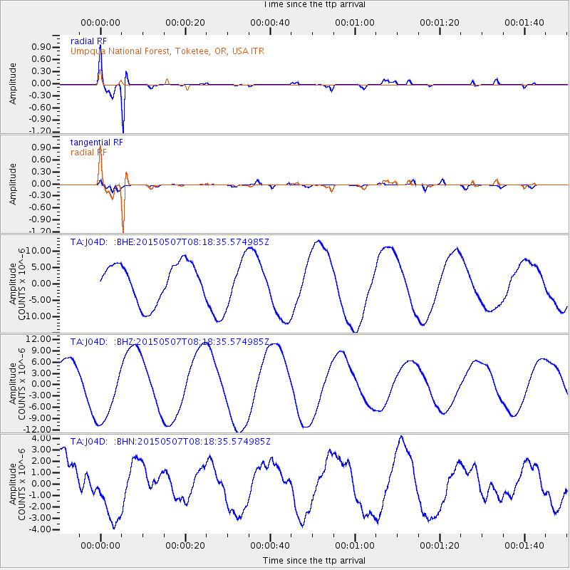
J04D Umpqua National Forest, Toketee, OR, USA - Earthquake Result Viewer
| Earthquake location: |
Solomon Islands |
| Earthquake latitude/longitude: |
-7.5/154.7 |
| Earthquake time(UTC): |
2015/05/07 (127) 08:06:09 GMT |
| Earthquake Depth: |
27 km |
| Earthquake Magnitude: |
5.2 mb |
| Earthquake Catalog/Contributor: |
ISC/ISC |
|
| Network: |
TA USArray Transportable Network (new EarthScope stations) |
| Station: |
J04D Umpqua National Forest, Toketee, OR, USA |
| Lat/Lon: |
43.24 N/122.11 W |
| Elevation: |
1948 m |
|
| Distance: |
90.2 deg |
| Az: |
46.526 deg |
| Baz: |
259.925 deg |
| Ray Param: |
0.041687496 |
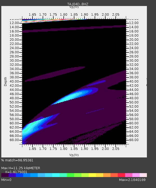
| Estimated Moho Depth: |
11.25 km |
| Estimated Crust Vp/Vs: |
1.62 |
| Assumed Crust Vp: |
6.522 km/s |
| Estimated Crust Vs: |
4.032 km/s |
| Estimated Crust Poisson's Ratio: |
0.19 |
|
| Radial Match: |
96.95361 % |
| Radial Bump: |
299 |
| Transverse Match: |
51.712303 % |
| Transverse Bump: |
400 |
| SOD ConfigId: |
7422571 |
| Insert Time: |
2019-04-18 17:36:31.747 +0000 |
| GWidth: |
2.5 |
| Max Bumps: |
400 |
| Tol: |
0.001 |
|
Signal To Noise
| Channel | StoN | STA | LTA |
| TA:J04D: :BHZ:20150507T08:18:35.574985Z | 1.8422666 | 8.189911E-6 | 4.4455624E-6 |
| TA:J04D: :BHN:20150507T08:18:35.574985Z | 1.3311349 | 2.549151E-6 | 1.915021E-6 |
| TA:J04D: :BHE:20150507T08:18:35.574985Z | 1.1956116 | 6.905352E-6 | 5.7755815E-6 |
| Arrivals |
| Ps | 1.1 SECOND |
| PpPs | 4.4 SECOND |
| PsPs/PpSs | 5.5 SECOND |


