You are here: Home > Network List > AK - Alaska Regional Network Stations List
> Station PWL Port Wells, AK, USA > Earthquake Result Viewer
PWL Port Wells, AK, USA - Earthquake Result Viewer
| Earthquake location: |
Solomon Islands |
| Earthquake latitude/longitude: |
-7.2/154.6 |
| Earthquake time(UTC): |
2015/05/07 (127) 08:12:41 GMT |
| Earthquake Depth: |
39 km |
| Earthquake Magnitude: |
5.0 mb |
| Earthquake Catalog/Contributor: |
ISC/ISC |
|
| Network: |
AK Alaska Regional Network |
| Station: |
PWL Port Wells, AK, USA |
| Lat/Lon: |
60.86 N/148.33 W |
| Elevation: |
555 m |
|
| Distance: |
81.1 deg |
| Az: |
24.586 deg |
| Baz: |
237.502 deg |
| Ray Param: |
0.04777328 |
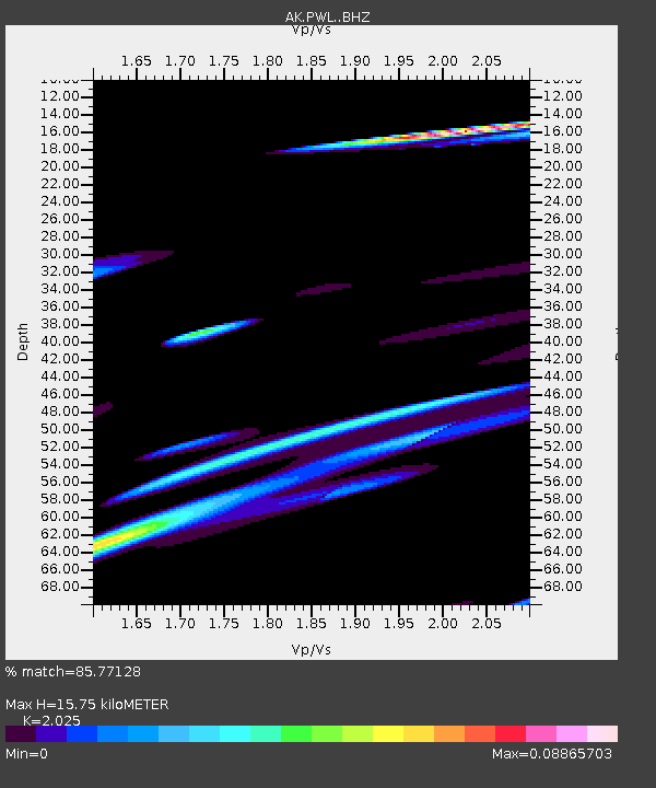
| Estimated Moho Depth: |
15.75 km |
| Estimated Crust Vp/Vs: |
2.03 |
| Assumed Crust Vp: |
6.566 km/s |
| Estimated Crust Vs: |
3.243 km/s |
| Estimated Crust Poisson's Ratio: |
0.34 |
|
| Radial Match: |
85.77128 % |
| Radial Bump: |
400 |
| Transverse Match: |
83.45533 % |
| Transverse Bump: |
400 |
| SOD ConfigId: |
7422571 |
| Insert Time: |
2019-04-18 17:38:16.931 +0000 |
| GWidth: |
2.5 |
| Max Bumps: |
400 |
| Tol: |
0.001 |
|

Signal To Noise
| Channel | StoN | STA | LTA |
| AK:PWL: :BHZ:20150507T08:24:21.828025Z | 1.7716609 | 4.489321E-6 | 2.5339618E-6 |
| AK:PWL: :BHN:20150507T08:24:21.828025Z | 0.8445419 | 2.2193242E-6 | 2.6278437E-6 |
| AK:PWL: :BHE:20150507T08:24:21.828025Z | 1.5690075 | 2.6908904E-6 | 1.715027E-6 |
| Arrivals |
| Ps | 2.5 SECOND |
| PpPs | 7.1 SECOND |
| PsPs/PpSs | 9.6 SECOND |


