You are here: Home > Network List > AV - Alaska Volcano Observatory Stations List
> Station MNAT Nateekin Bay, Makushin Volcano, Alaska > Earthquake Result Viewer
MNAT Nateekin Bay, Makushin Volcano, Alaska - Earthquake Result Viewer
| Earthquake location: |
Solomon Islands |
| Earthquake latitude/longitude: |
-7.2/154.6 |
| Earthquake time(UTC): |
2015/05/07 (127) 08:12:41 GMT |
| Earthquake Depth: |
39 km |
| Earthquake Magnitude: |
5.0 mb |
| Earthquake Catalog/Contributor: |
ISC/ISC |
|
| Network: |
AV Alaska Volcano Observatory |
| Station: |
MNAT Nateekin Bay, Makushin Volcano, Alaska |
| Lat/Lon: |
53.88 N/166.69 W |
| Elevation: |
390 m |
|
| Distance: |
69.1 deg |
| Az: |
23.384 deg |
| Baz: |
221.696 deg |
| Ray Param: |
0.055835888 |
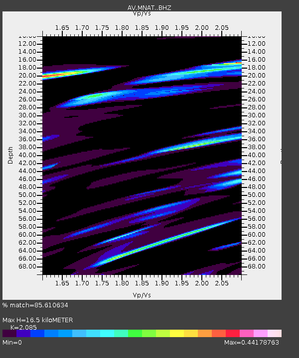
| Estimated Moho Depth: |
16.5 km |
| Estimated Crust Vp/Vs: |
2.09 |
| Assumed Crust Vp: |
3.943 km/s |
| Estimated Crust Vs: |
1.891 km/s |
| Estimated Crust Poisson's Ratio: |
0.35 |
|
| Radial Match: |
85.610634 % |
| Radial Bump: |
368 |
| Transverse Match: |
88.303696 % |
| Transverse Bump: |
400 |
| SOD ConfigId: |
7422571 |
| Insert Time: |
2019-04-18 17:38:36.957 +0000 |
| GWidth: |
2.5 |
| Max Bumps: |
400 |
| Tol: |
0.001 |
|
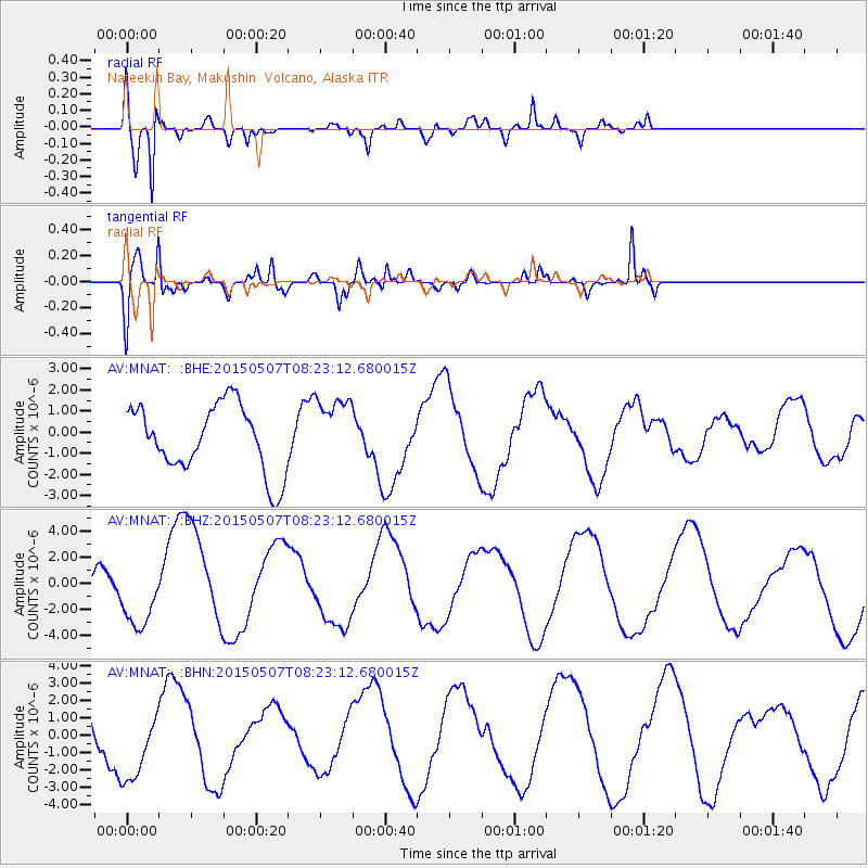
Signal To Noise
| Channel | StoN | STA | LTA |
| AV:MNAT: :BHZ:20150507T08:23:12.680015Z | 1.2429438 | 2.5197564E-6 | 2.0272487E-6 |
| AV:MNAT: :BHN:20150507T08:23:12.680015Z | 1.5814 | 2.1563308E-6 | 1.363558E-6 |
| AV:MNAT: :BHE:20150507T08:23:12.680015Z | 1.0421582 | 1.6463706E-6 | 1.5797701E-6 |
| Arrivals |
| Ps | 4.6 SECOND |
| PpPs | 13 SECOND |
| PsPs/PpSs | 17 SECOND |


