You are here: Home > Network List > CI - Caltech Regional Seismic Network Stations List
> Station FMP Fort MacArthur Park, Pt. Fermin San Pedro, CA, USA > Earthquake Result Viewer
FMP Fort MacArthur Park, Pt. Fermin San Pedro, CA, USA - Earthquake Result Viewer
| Earthquake location: |
Solomon Islands |
| Earthquake latitude/longitude: |
-7.2/154.6 |
| Earthquake time(UTC): |
2015/05/07 (127) 08:12:41 GMT |
| Earthquake Depth: |
39 km |
| Earthquake Magnitude: |
5.0 mb |
| Earthquake Catalog/Contributor: |
ISC/ISC |
|
| Network: |
CI Caltech Regional Seismic Network |
| Station: |
FMP Fort MacArthur Park, Pt. Fermin San Pedro, CA, USA |
| Lat/Lon: |
33.71 N/118.29 W |
| Elevation: |
89 m |
|
| Distance: |
91.6 deg |
| Az: |
56.392 deg |
| Baz: |
262.462 deg |
| Ray Param: |
0.041574866 |
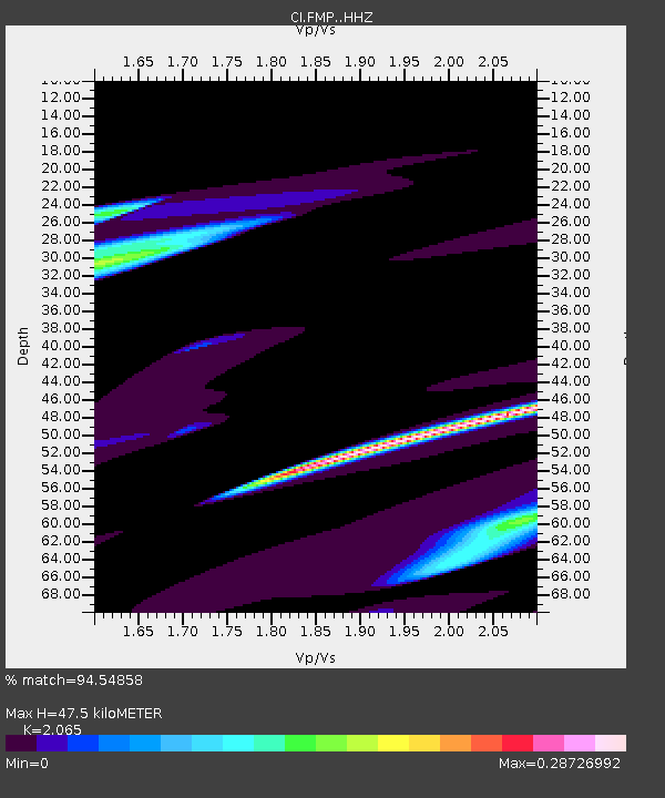
| Estimated Moho Depth: |
47.5 km |
| Estimated Crust Vp/Vs: |
2.07 |
| Assumed Crust Vp: |
6.048 km/s |
| Estimated Crust Vs: |
2.929 km/s |
| Estimated Crust Poisson's Ratio: |
0.35 |
|
| Radial Match: |
94.54858 % |
| Radial Bump: |
400 |
| Transverse Match: |
68.20618 % |
| Transverse Bump: |
400 |
| SOD ConfigId: |
7422571 |
| Insert Time: |
2019-04-18 17:39:01.893 +0000 |
| GWidth: |
2.5 |
| Max Bumps: |
400 |
| Tol: |
0.001 |
|

Signal To Noise
| Channel | StoN | STA | LTA |
| CI:FMP: :HHZ:20150507T08:25:13.328025Z | 1.2931811 | 4.124407E-6 | 3.1893499E-6 |
| CI:FMP: :HHN:20150507T08:25:13.328025Z | 1.5982488 | 3.5295243E-6 | 2.2083698E-6 |
| CI:FMP: :HHE:20150507T08:25:13.328025Z | 1.1869987 | 5.119736E-6 | 4.313177E-6 |
| Arrivals |
| Ps | 8.5 SECOND |
| PpPs | 24 SECOND |
| PsPs/PpSs | 32 SECOND |


