You are here: Home > Network List > TA - USArray Transportable Network (new EarthScope stations) Stations List
> Station MSTX Muleshoe, TX, USA > Earthquake Result Viewer
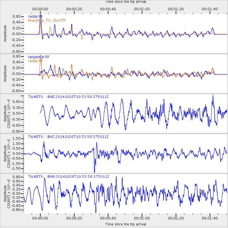
MSTX Muleshoe, TX, USA - Earthquake Result Viewer
*The percent match for this event was below the threshold and hence no stack was calculated.
| Earthquake location: |
Central Peru |
| Earthquake latitude/longitude: |
-10.5/-74.1 |
| Earthquake time(UTC): |
2014/10/26 (299) 10:45:32 GMT |
| Earthquake Depth: |
123 km |
| Earthquake Magnitude: |
5.6 MB, 5.7 MWB |
| Earthquake Catalog/Contributor: |
NEIC PDE/NEIC COMCAT |
|
| Network: |
TA USArray Transportable Network (new EarthScope stations) |
| Station: |
MSTX Muleshoe, TX, USA |
| Lat/Lon: |
33.97 N/102.77 W |
| Elevation: |
1167 m |
|
| Distance: |
52.0 deg |
| Az: |
329.636 deg |
| Baz: |
143.265 deg |
| Ray Param: |
$rayparam |
*The percent match for this event was below the threshold and hence was not used in the summary stack. |
|
| Radial Match: |
62.399334 % |
| Radial Bump: |
400 |
| Transverse Match: |
45.86105 % |
| Transverse Bump: |
378 |
| SOD ConfigId: |
811962 |
| Insert Time: |
2014-11-09 11:23:48.834 +0000 |
| GWidth: |
2.5 |
| Max Bumps: |
400 |
| Tol: |
0.001 |
|
Signal To Noise
| Channel | StoN | STA | LTA |
| TA:MSTX: :BHZ:20141026T10:53:58.375011Z | 1.8711429 | 4.9807426E-7 | 2.661872E-7 |
| TA:MSTX: :BHN:20141026T10:53:58.375011Z | 1.4961768 | 4.3995686E-7 | 2.9405405E-7 |
| TA:MSTX: :BHE:20141026T10:53:58.375011Z | 0.87020355 | 2.0104815E-7 | 2.3103577E-7 |
| Arrivals |
| Ps | |
| PpPs | |
| PsPs/PpSs | |


