You are here: Home > Network List > TA - USArray Transportable Network (new EarthScope stations) Stations List
> Station P59A Jarrettsville, MD, USA > Earthquake Result Viewer
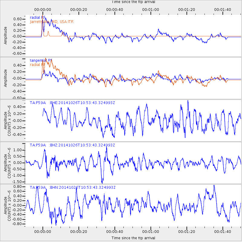
P59A Jarrettsville, MD, USA - Earthquake Result Viewer
*The percent match for this event was below the threshold and hence no stack was calculated.
| Earthquake location: |
Central Peru |
| Earthquake latitude/longitude: |
-10.5/-74.1 |
| Earthquake time(UTC): |
2014/10/26 (299) 10:45:32 GMT |
| Earthquake Depth: |
123 km |
| Earthquake Magnitude: |
5.6 MB, 5.7 MWB |
| Earthquake Catalog/Contributor: |
NEIC PDE/NEIC COMCAT |
|
| Network: |
TA USArray Transportable Network (new EarthScope stations) |
| Station: |
P59A Jarrettsville, MD, USA |
| Lat/Lon: |
39.61 N/76.43 W |
| Elevation: |
157 m |
|
| Distance: |
49.9 deg |
| Az: |
357.694 deg |
| Baz: |
177.065 deg |
| Ray Param: |
$rayparam |
*The percent match for this event was below the threshold and hence was not used in the summary stack. |
|
| Radial Match: |
50.790215 % |
| Radial Bump: |
400 |
| Transverse Match: |
45.634846 % |
| Transverse Bump: |
400 |
| SOD ConfigId: |
811962 |
| Insert Time: |
2014-11-09 11:24:28.107 +0000 |
| GWidth: |
2.5 |
| Max Bumps: |
400 |
| Tol: |
0.001 |
|
Signal To Noise
| Channel | StoN | STA | LTA |
| TA:P59A: :BHZ:20141026T10:53:43.324993Z | 2.9979527 | 6.3284216E-7 | 2.1109145E-7 |
| TA:P59A: :BHN:20141026T10:53:43.324993Z | 1.6831074 | 3.718812E-7 | 2.2094918E-7 |
| TA:P59A: :BHE:20141026T10:53:43.324993Z | 1.6156628 | 2.9104157E-7 | 1.8013756E-7 |
| Arrivals |
| Ps | |
| PpPs | |
| PsPs/PpSs | |


