You are here: Home > Network List > TA - USArray Transportable Network (new EarthScope stations) Stations List
> Station T57A Hurt, VA, USA > Earthquake Result Viewer
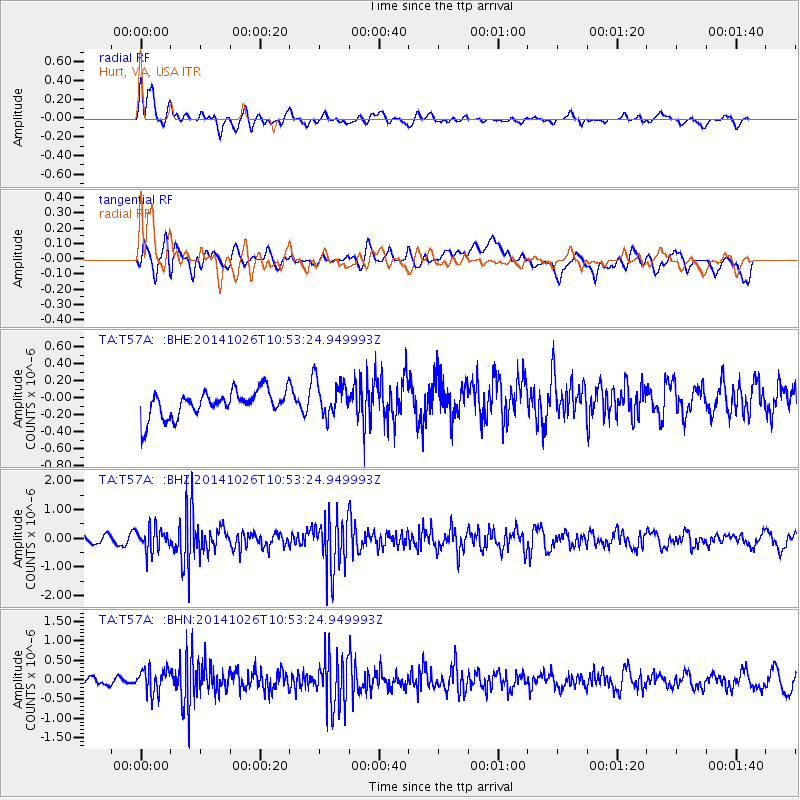
T57A Hurt, VA, USA - Earthquake Result Viewer
*The percent match for this event was below the threshold and hence no stack was calculated.
| Earthquake location: |
Central Peru |
| Earthquake latitude/longitude: |
-10.5/-74.1 |
| Earthquake time(UTC): |
2014/10/26 (299) 10:45:32 GMT |
| Earthquake Depth: |
123 km |
| Earthquake Magnitude: |
5.6 MB, 5.7 MWB |
| Earthquake Catalog/Contributor: |
NEIC PDE/NEIC COMCAT |
|
| Network: |
TA USArray Transportable Network (new EarthScope stations) |
| Station: |
T57A Hurt, VA, USA |
| Lat/Lon: |
37.00 N/79.25 W |
| Elevation: |
230 m |
|
| Distance: |
47.5 deg |
| Az: |
354.458 deg |
| Baz: |
173.187 deg |
| Ray Param: |
$rayparam |
*The percent match for this event was below the threshold and hence was not used in the summary stack. |
|
| Radial Match: |
72.774796 % |
| Radial Bump: |
400 |
| Transverse Match: |
50.427773 % |
| Transverse Bump: |
400 |
| SOD ConfigId: |
811962 |
| Insert Time: |
2014-11-09 11:25:22.246 +0000 |
| GWidth: |
2.5 |
| Max Bumps: |
400 |
| Tol: |
0.001 |
|
Signal To Noise
| Channel | StoN | STA | LTA |
| TA:T57A: :BHZ:20141026T10:53:24.949993Z | 2.2193766 | 4.008004E-7 | 1.8059144E-7 |
| TA:T57A: :BHN:20141026T10:53:24.949993Z | 3.12456 | 3.140187E-7 | 1.0050013E-7 |
| TA:T57A: :BHE:20141026T10:53:24.949993Z | 1.3634814 | 2.0989543E-7 | 1.539408E-7 |
| Arrivals |
| Ps | |
| PpPs | |
| PsPs/PpSs | |


