You are here: Home > Network List > TA - USArray Transportable Network (new EarthScope stations) Stations List
> Station J01E Myrtle Point, OR, USA > Earthquake Result Viewer
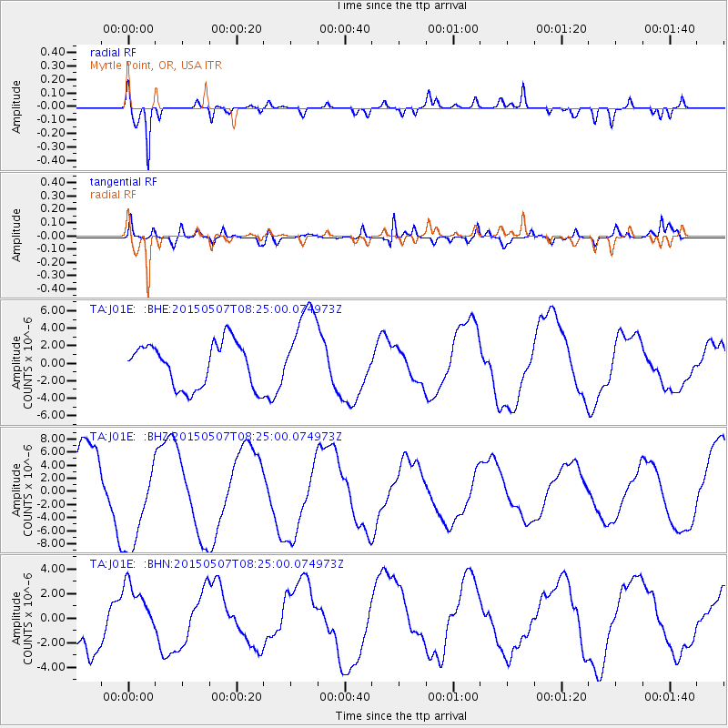
J01E Myrtle Point, OR, USA - Earthquake Result Viewer
*The percent match for this event was below the threshold and hence no stack was calculated.
| Earthquake location: |
Solomon Islands |
| Earthquake latitude/longitude: |
-7.2/154.6 |
| Earthquake time(UTC): |
2015/05/07 (127) 08:12:41 GMT |
| Earthquake Depth: |
39 km |
| Earthquake Magnitude: |
5.0 mb |
| Earthquake Catalog/Contributor: |
ISC/ISC |
|
| Network: |
TA USArray Transportable Network (new EarthScope stations) |
| Station: |
J01E Myrtle Point, OR, USA |
| Lat/Lon: |
43.16 N/123.93 W |
| Elevation: |
128 m |
|
| Distance: |
88.7 deg |
| Az: |
46.376 deg |
| Baz: |
258.986 deg |
| Ray Param: |
$rayparam |
*The percent match for this event was below the threshold and hence was not used in the summary stack. |
|
| Radial Match: |
88.5973 % |
| Radial Bump: |
400 |
| Transverse Match: |
72.22877 % |
| Transverse Bump: |
400 |
| SOD ConfigId: |
7422571 |
| Insert Time: |
2019-04-18 17:40:48.729 +0000 |
| GWidth: |
2.5 |
| Max Bumps: |
400 |
| Tol: |
0.001 |
|
Signal To Noise
| Channel | StoN | STA | LTA |
| TA:J01E: :BHZ:20150507T08:25:00.074973Z | 1.2674409 | 6.945173E-6 | 5.479682E-6 |
| TA:J01E: :BHN:20150507T08:25:00.074973Z | 1.0129776 | 2.2710149E-6 | 2.2419201E-6 |
| TA:J01E: :BHE:20150507T08:25:00.074973Z | 1.9497097 | 4.9374607E-6 | 2.5324082E-6 |
| Arrivals |
| Ps | |
| PpPs | |
| PsPs/PpSs | |


