You are here: Home > Network List > TA - USArray Transportable Network (new EarthScope stations) Stations List
> Station V60A Jim Taylor Road, Stokes, NC, USA > Earthquake Result Viewer
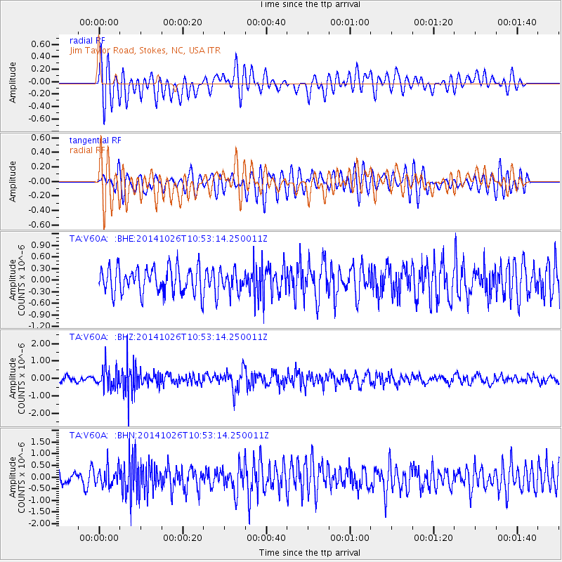
V60A Jim Taylor Road, Stokes, NC, USA - Earthquake Result Viewer
*The percent match for this event was below the threshold and hence no stack was calculated.
| Earthquake location: |
Central Peru |
| Earthquake latitude/longitude: |
-10.5/-74.1 |
| Earthquake time(UTC): |
2014/10/26 (299) 10:45:32 GMT |
| Earthquake Depth: |
123 km |
| Earthquake Magnitude: |
5.6 MB, 5.7 MWB |
| Earthquake Catalog/Contributor: |
NEIC PDE/NEIC COMCAT |
|
| Network: |
TA USArray Transportable Network (new EarthScope stations) |
| Station: |
V60A Jim Taylor Road, Stokes, NC, USA |
| Lat/Lon: |
35.76 N/77.26 W |
| Elevation: |
8.0 m |
|
| Distance: |
46.2 deg |
| Az: |
356.487 deg |
| Baz: |
175.752 deg |
| Ray Param: |
$rayparam |
*The percent match for this event was below the threshold and hence was not used in the summary stack. |
|
| Radial Match: |
56.05528 % |
| Radial Bump: |
400 |
| Transverse Match: |
54.407566 % |
| Transverse Bump: |
400 |
| SOD ConfigId: |
811962 |
| Insert Time: |
2014-11-09 11:25:56.301 +0000 |
| GWidth: |
2.5 |
| Max Bumps: |
400 |
| Tol: |
0.001 |
|
Signal To Noise
| Channel | StoN | STA | LTA |
| TA:V60A: :BHZ:20141026T10:53:14.250011Z | 2.9528375 | 5.6415837E-7 | 1.9105636E-7 |
| TA:V60A: :BHN:20141026T10:53:14.250011Z | 1.4179159 | 4.0536986E-7 | 2.858913E-7 |
| TA:V60A: :BHE:20141026T10:53:14.250011Z | 0.7667839 | 2.5447744E-7 | 3.3187638E-7 |
| Arrivals |
| Ps | |
| PpPs | |
| PsPs/PpSs | |


