You are here: Home > Network List > IU - Global Seismograph Network (GSN - IRIS/USGS) Stations List
> Station HKT Hockley, Texas > Earthquake Result Viewer
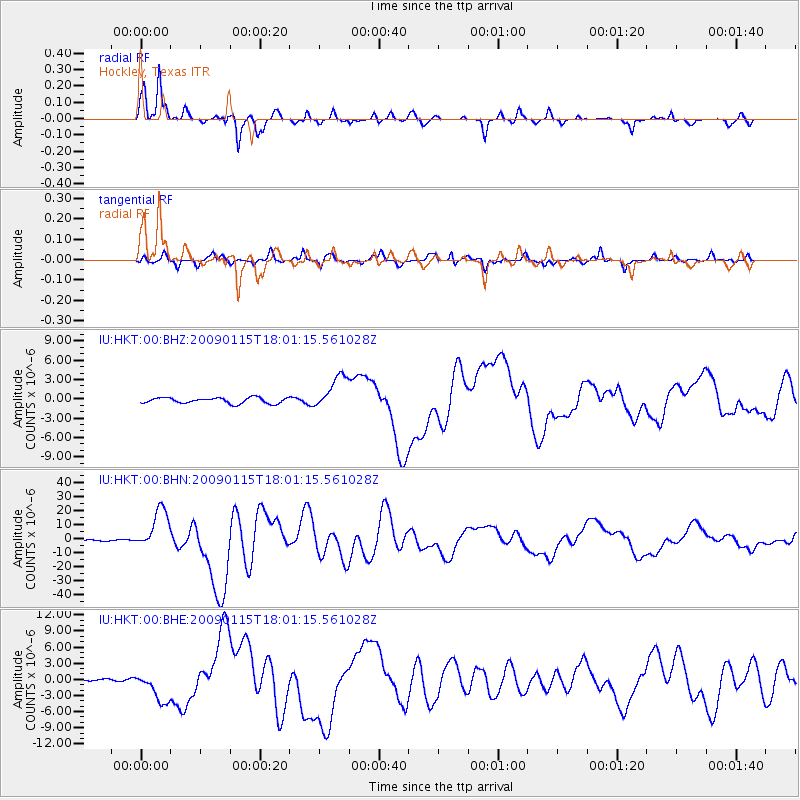
HKT Hockley, Texas - Earthquake Result Viewer
*The percent match for this event was below the threshold and hence no stack was calculated.
| Earthquake location: |
East Of Kuril Islands |
| Earthquake latitude/longitude: |
46.9/155.2 |
| Earthquake time(UTC): |
2009/01/15 (015) 17:49:39 GMT |
| Earthquake Depth: |
36 km |
| Earthquake Magnitude: |
6.9 MB, 7.5 MS, 7.4 MW, 7.4 MW |
| Earthquake Catalog/Contributor: |
WHDF/NEIC |
|
| Network: |
IU Global Seismograph Network (GSN - IRIS/USGS) |
| Station: |
HKT Hockley, Texas |
| Lat/Lon: |
29.96 N/95.84 W |
| Elevation: |
-413.0 m |
|
| Distance: |
80.4 deg |
| Az: |
56.33 deg |
| Baz: |
318.842 deg |
| Ray Param: |
$rayparam |
*The percent match for this event was below the threshold and hence was not used in the summary stack. |
|
| Radial Match: |
95.90928 % |
| Radial Bump: |
277 |
| Transverse Match: |
91.83872 % |
| Transverse Bump: |
400 |
| SOD ConfigId: |
2834 |
| Insert Time: |
2010-03-02 13:58:12.263 +0000 |
| GWidth: |
2.5 |
| Max Bumps: |
400 |
| Tol: |
0.001 |
|
Signal To Noise
| Channel | StoN | STA | LTA |
| IU:HKT:00:BHN:20090115T18:01:15.561028Z | 32.367138 | 1.4671225E-5 | 4.532753E-7 |
| IU:HKT:00:BHE:20090115T18:01:15.561028Z | 8.14505 | 2.8322909E-6 | 3.4773157E-7 |
| IU:HKT:00:BHZ:20090115T18:01:15.561028Z | 5.9619474 | 2.6722712E-6 | 4.482212E-7 |
| Arrivals |
| Ps | |
| PpPs | |
| PsPs/PpSs | |


