You are here: Home > Network List > US - United States National Seismic Network Stations List
> Station GLMI Grayling, Michigan, USA > Earthquake Result Viewer
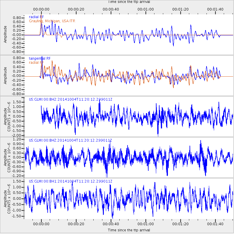
GLMI Grayling, Michigan, USA - Earthquake Result Viewer
*The percent match for this event was below the threshold and hence no stack was calculated.
| Earthquake location: |
Virgin Islands |
| Earthquake latitude/longitude: |
19.2/-64.9 |
| Earthquake time(UTC): |
2014/10/04 (277) 11:14:33 GMT |
| Earthquake Depth: |
29 km |
| Earthquake Magnitude: |
5.5 MWW, 3.0 MD, 3.0 MD, 5.5 MWB, 5.6 MWC |
| Earthquake Catalog/Contributor: |
NEIC PDE/NEIC COMCAT |
|
| Network: |
US United States National Seismic Network |
| Station: |
GLMI Grayling, Michigan, USA |
| Lat/Lon: |
44.82 N/84.62 W |
| Elevation: |
387 m |
|
| Distance: |
30.4 deg |
| Az: |
331.568 deg |
| Baz: |
140.794 deg |
| Ray Param: |
$rayparam |
*The percent match for this event was below the threshold and hence was not used in the summary stack. |
|
| Radial Match: |
47.558315 % |
| Radial Bump: |
400 |
| Transverse Match: |
54.365578 % |
| Transverse Bump: |
400 |
| SOD ConfigId: |
811962 |
| Insert Time: |
2014-11-10 18:43:20.444 +0000 |
| GWidth: |
2.5 |
| Max Bumps: |
400 |
| Tol: |
0.001 |
|
Signal To Noise
| Channel | StoN | STA | LTA |
| US:GLMI:00:BHZ:20141004T11:20:12.299011Z | 0.7326525 | 3.0085087E-7 | 4.1063242E-7 |
| US:GLMI:00:BH1:20141004T11:20:12.299011Z | 0.77986485 | 4.3116086E-7 | 5.5286614E-7 |
| US:GLMI:00:BH2:20141004T11:20:12.299011Z | 1.0056795 | 5.807404E-7 | 5.7746064E-7 |
| Arrivals |
| Ps | |
| PpPs | |
| PsPs/PpSs | |


