You are here: Home > Network List > UU - University of Utah Regional Network Stations List
> Station CCUT Cedar City, UT, USA > Earthquake Result Viewer
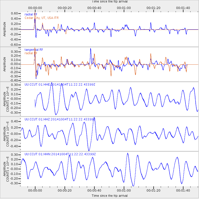
CCUT Cedar City, UT, USA - Earthquake Result Viewer
*The percent match for this event was below the threshold and hence no stack was calculated.
| Earthquake location: |
Virgin Islands |
| Earthquake latitude/longitude: |
19.2/-64.9 |
| Earthquake time(UTC): |
2014/10/04 (277) 11:14:33 GMT |
| Earthquake Depth: |
29 km |
| Earthquake Magnitude: |
5.5 MWW, 3.0 MD, 3.0 MD, 5.5 MWB, 5.6 MWC |
| Earthquake Catalog/Contributor: |
NEIC PDE/NEIC COMCAT |
|
| Network: |
UU University of Utah Regional Network |
| Station: |
CCUT Cedar City, UT, USA |
| Lat/Lon: |
37.55 N/113.36 W |
| Elevation: |
2127 m |
|
| Distance: |
45.9 deg |
| Az: |
303.956 deg |
| Baz: |
99.587 deg |
| Ray Param: |
$rayparam |
*The percent match for this event was below the threshold and hence was not used in the summary stack. |
|
| Radial Match: |
61.943157 % |
| Radial Bump: |
400 |
| Transverse Match: |
57.05587 % |
| Transverse Bump: |
400 |
| SOD ConfigId: |
811962 |
| Insert Time: |
2014-11-10 18:43:49.973 +0000 |
| GWidth: |
2.5 |
| Max Bumps: |
400 |
| Tol: |
0.001 |
|
Signal To Noise
| Channel | StoN | STA | LTA |
| UU:CCUT:01:HHZ:20141004T11:22:22.43399Z | 1.7252673 | 2.1766787E-7 | 1.2616472E-7 |
| UU:CCUT:01:HHN:20141004T11:22:22.43399Z | 0.7334136 | 1.1643E-7 | 1.5875081E-7 |
| UU:CCUT:01:HHE:20141004T11:22:22.43399Z | 0.802485 | 1.5401619E-7 | 1.9192406E-7 |
| Arrivals |
| Ps | |
| PpPs | |
| PsPs/PpSs | |


