You are here: Home > Network List > TA - USArray Transportable Network (new EarthScope stations) Stations List
> Station M04C Macdoel, CA, USA > Earthquake Result Viewer
M04C Macdoel, CA, USA - Earthquake Result Viewer
| Earthquake location: |
Solomon Islands |
| Earthquake latitude/longitude: |
-7.5/154.8 |
| Earthquake time(UTC): |
2015/05/07 (127) 08:50:57 GMT |
| Earthquake Depth: |
31 km |
| Earthquake Magnitude: |
4.9 mb |
| Earthquake Catalog/Contributor: |
ISC/ISC |
|
| Network: |
TA USArray Transportable Network (new EarthScope stations) |
| Station: |
M04C Macdoel, CA, USA |
| Lat/Lon: |
41.78 N/121.84 W |
| Elevation: |
1391 m |
|
| Distance: |
90.0 deg |
| Az: |
47.979 deg |
| Baz: |
260.058 deg |
| Ray Param: |
0.04169992 |
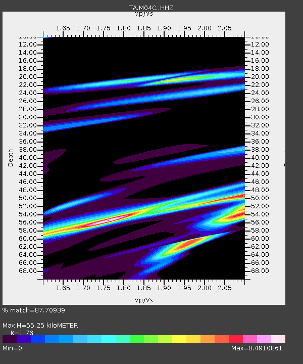
| Estimated Moho Depth: |
55.25 km |
| Estimated Crust Vp/Vs: |
1.76 |
| Assumed Crust Vp: |
6.566 km/s |
| Estimated Crust Vs: |
3.731 km/s |
| Estimated Crust Poisson's Ratio: |
0.26 |
|
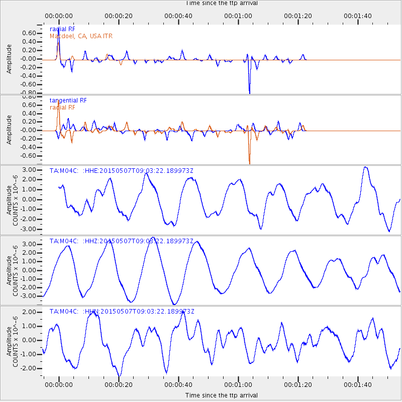
| Radial Match: |
87.70939 % |
| Radial Bump: |
387 |
| Transverse Match: |
56.423943 % |
| Transverse Bump: |
400 |
| SOD ConfigId: |
7422571 |
| Insert Time: |
2019-04-18 17:45:00.032 +0000 |
| GWidth: |
2.5 |
| Max Bumps: |
400 |
| Tol: |
0.001 |
|
Signal To Noise
| Channel | StoN | STA | LTA |
| TA:M04C: :HHZ:20150507T09:03:22.189973Z | 1.7324159 | 2.266732E-6 | 1.3084226E-6 |
| TA:M04C: :HHN:20150507T09:03:22.189973Z | 2.8720021 | 1.2897158E-6 | 4.4906506E-7 |
| TA:M04C: :HHE:20150507T09:03:22.189973Z | 1.5278836 | 1.7772933E-6 | 1.1632386E-6 |
| Arrivals |
| Ps | 6.5 SECOND |
| PpPs | 23 SECOND |
| PsPs/PpSs | 29 SECOND |


