You are here: Home > Network List > TA - USArray Transportable Network (new EarthScope stations) Stations List
> Station TPFO Pinon Flats, CA, USA > Earthquake Result Viewer
TPFO Pinon Flats, CA, USA - Earthquake Result Viewer
| Earthquake location: |
Solomon Islands |
| Earthquake latitude/longitude: |
-7.5/154.8 |
| Earthquake time(UTC): |
2015/05/07 (127) 08:50:57 GMT |
| Earthquake Depth: |
31 km |
| Earthquake Magnitude: |
4.9 mb |
| Earthquake Catalog/Contributor: |
ISC/ISC |
|
| Network: |
TA USArray Transportable Network (new EarthScope stations) |
| Station: |
TPFO Pinon Flats, CA, USA |
| Lat/Lon: |
33.61 N/116.45 W |
| Elevation: |
1275 m |
|
| Distance: |
93.1 deg |
| Az: |
56.675 deg |
| Baz: |
263.114 deg |
| Ray Param: |
0.041326307 |
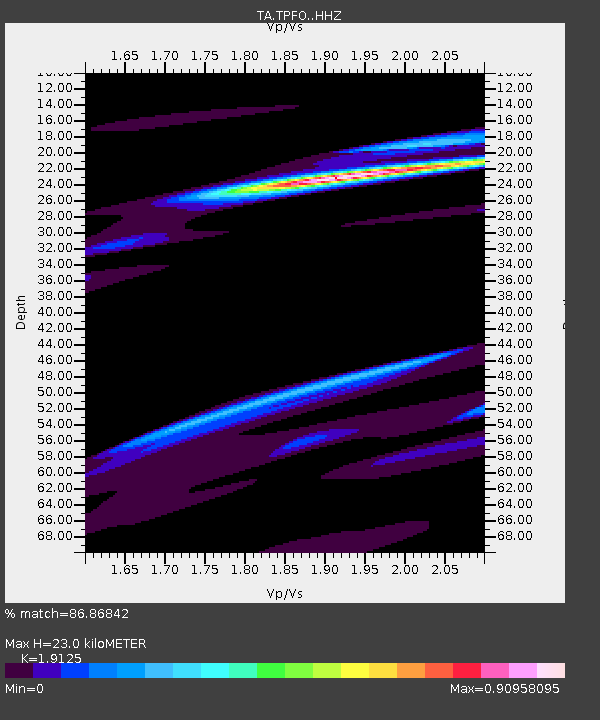
| Estimated Moho Depth: |
23.0 km |
| Estimated Crust Vp/Vs: |
1.91 |
| Assumed Crust Vp: |
6.264 km/s |
| Estimated Crust Vs: |
3.275 km/s |
| Estimated Crust Poisson's Ratio: |
0.31 |
|
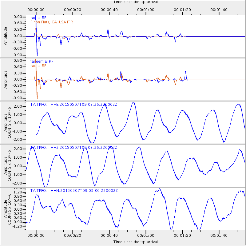
| Radial Match: |
86.86842 % |
| Radial Bump: |
389 |
| Transverse Match: |
66.31138 % |
| Transverse Bump: |
264 |
| SOD ConfigId: |
7422571 |
| Insert Time: |
2019-04-18 17:45:01.919 +0000 |
| GWidth: |
2.5 |
| Max Bumps: |
400 |
| Tol: |
0.001 |
|
Signal To Noise
| Channel | StoN | STA | LTA |
| TA:TPFO: :HHZ:20150507T09:03:36.220002Z | 1.6272396 | 1.3487027E-6 | 8.288286E-7 |
| TA:TPFO: :HHN:20150507T09:03:36.220002Z | 0.82192224 | 7.005849E-7 | 8.5237366E-7 |
| TA:TPFO: :HHE:20150507T09:03:36.220002Z | 2.394446 | 1.971393E-6 | 8.2331906E-7 |
| Arrivals |
| Ps | 3.4 SECOND |
| PpPs | 11 SECOND |
| PsPs/PpSs | 14 SECOND |


