You are here: Home > Network List > TA - USArray Transportable Network (new EarthScope stations) Stations List
> Station R11A Troy Canyon, Currant, NV, USA > Earthquake Result Viewer
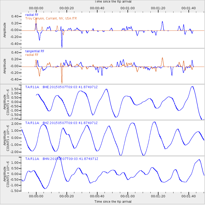
R11A Troy Canyon, Currant, NV, USA - Earthquake Result Viewer
*The percent match for this event was below the threshold and hence no stack was calculated.
| Earthquake location: |
Solomon Islands |
| Earthquake latitude/longitude: |
-7.5/154.8 |
| Earthquake time(UTC): |
2015/05/07 (127) 08:50:57 GMT |
| Earthquake Depth: |
31 km |
| Earthquake Magnitude: |
4.9 mb |
| Earthquake Catalog/Contributor: |
ISC/ISC |
|
| Network: |
TA USArray Transportable Network (new EarthScope stations) |
| Station: |
R11A Troy Canyon, Currant, NV, USA |
| Lat/Lon: |
38.35 N/115.59 W |
| Elevation: |
1756 m |
|
| Distance: |
94.3 deg |
| Az: |
52.042 deg |
| Baz: |
263.919 deg |
| Ray Param: |
$rayparam |
*The percent match for this event was below the threshold and hence was not used in the summary stack. |
|
| Radial Match: |
80.543915 % |
| Radial Bump: |
354 |
| Transverse Match: |
59.79151 % |
| Transverse Bump: |
400 |
| SOD ConfigId: |
7422571 |
| Insert Time: |
2019-04-18 17:45:02.520 +0000 |
| GWidth: |
2.5 |
| Max Bumps: |
400 |
| Tol: |
0.001 |
|
Signal To Noise
| Channel | StoN | STA | LTA |
| TA:R11A: :BHZ:20150507T09:03:41.874971Z | 2.0745885 | 1.2830122E-6 | 6.184418E-7 |
| TA:R11A: :BHN:20150507T09:03:41.874971Z | 1.4433628 | 6.3289934E-7 | 4.3848942E-7 |
| TA:R11A: :BHE:20150507T09:03:41.874971Z | 1.5384216 | 1.1972487E-6 | 7.782318E-7 |
| Arrivals |
| Ps | |
| PpPs | |
| PsPs/PpSs | |


