You are here: Home > Network List > CI - Caltech Regional Seismic Network Stations List
> Station CWC Cottonwood Creek, Lone Pine, CA, USA > Earthquake Result Viewer
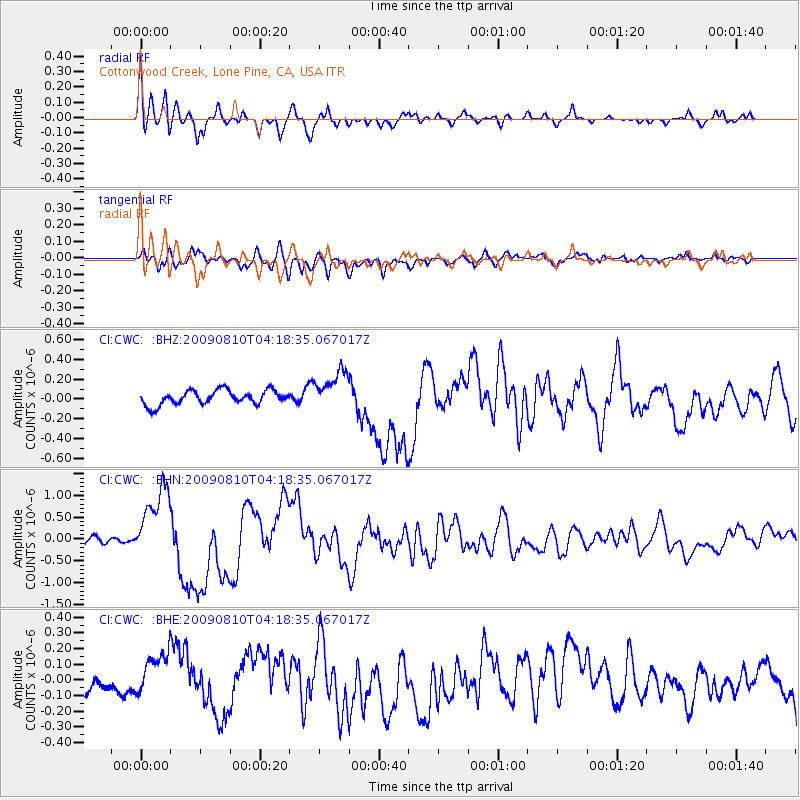
CWC Cottonwood Creek, Lone Pine, CA, USA - Earthquake Result Viewer
| Earthquake location: |
Santa Cruz Islands |
| Earthquake latitude/longitude: |
-11.6/166.1 |
| Earthquake time(UTC): |
2009/08/10 (222) 04:06:31 GMT |
| Earthquake Depth: |
35 km |
| Earthquake Magnitude: |
5.8 MB, 6.3 MS, 6.6 MW, 6.6 MW |
| Earthquake Catalog/Contributor: |
WHDF/NEIC |
|
| Network: |
CI Caltech Regional Seismic Network |
| Station: |
CWC Cottonwood Creek, Lone Pine, CA, USA |
| Lat/Lon: |
36.44 N/118.08 W |
| Elevation: |
1595 m |
|
| Distance: |
85.7 deg |
| Az: |
51.634 deg |
| Baz: |
252.303 deg |
| Ray Param: |
0.04453636 |
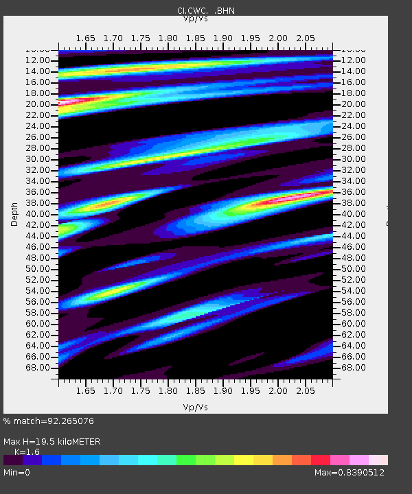
| Estimated Moho Depth: |
19.5 km |
| Estimated Crust Vp/Vs: |
1.60 |
| Assumed Crust Vp: |
6.291 km/s |
| Estimated Crust Vs: |
3.932 km/s |
| Estimated Crust Poisson's Ratio: |
0.18 |
|
| Radial Match: |
92.265076 % |
| Radial Bump: |
400 |
| Transverse Match: |
60.782898 % |
| Transverse Bump: |
400 |
| SOD ConfigId: |
2622 |
| Insert Time: |
2010-02-25 21:20:36.022 +0000 |
| GWidth: |
2.5 |
| Max Bumps: |
400 |
| Tol: |
0.001 |
|
Signal To Noise
| Channel | StoN | STA | LTA |
| CI:CWC: :BHN:20090810T04:18:35.067017Z | 11.808904 | 8.5611947E-7 | 7.249779E-8 |
| CI:CWC: :BHE:20090810T04:18:35.067017Z | 3.5808213 | 1.628702E-7 | 4.5484033E-8 |
| CI:CWC: :BHZ:20090810T04:18:35.067017Z | 2.7233016 | 1.9259201E-7 | 7.072005E-8 |
| Arrivals |
| Ps | 1.9 SECOND |
| PpPs | 7.9 SECOND |
| PsPs/PpSs | 9.8 SECOND |


