You are here: Home > Network List > IM - International Miscellaneous Stations Stations List
> Station IL31 ILAR Array, Eilson, AK, USA > Earthquake Result Viewer
IL31 ILAR Array, Eilson, AK, USA - Earthquake Result Viewer
| Earthquake location: |
Tonga Islands |
| Earthquake latitude/longitude: |
-15.2/-174.7 |
| Earthquake time(UTC): |
2014/10/28 (301) 03:15:43 GMT |
| Earthquake Depth: |
35 km |
| Earthquake Magnitude: |
5.5 MB, 6.1 MWC |
| Earthquake Catalog/Contributor: |
NEIC PDE/NEIC COMCAT |
|
| Network: |
IM International Miscellaneous Stations |
| Station: |
IL31 ILAR Array, Eilson, AK, USA |
| Lat/Lon: |
64.77 N/146.89 W |
| Elevation: |
419 m |
|
| Distance: |
82.5 deg |
| Az: |
11.623 deg |
| Baz: |
206.993 deg |
| Ray Param: |
0.046807457 |
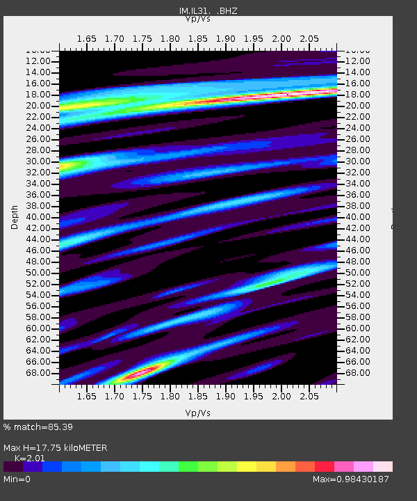
| Estimated Moho Depth: |
17.75 km |
| Estimated Crust Vp/Vs: |
2.01 |
| Assumed Crust Vp: |
6.566 km/s |
| Estimated Crust Vs: |
3.267 km/s |
| Estimated Crust Poisson's Ratio: |
0.34 |
|
| Radial Match: |
85.39 % |
| Radial Bump: |
400 |
| Transverse Match: |
72.48663 % |
| Transverse Bump: |
400 |
| SOD ConfigId: |
811962 |
| Insert Time: |
2014-11-11 03:44:22.674 +0000 |
| GWidth: |
2.5 |
| Max Bumps: |
400 |
| Tol: |
0.001 |
|

Signal To Noise
| Channel | StoN | STA | LTA |
| IM:IL31: :BHZ:20141028T03:27:31.174016Z | 4.1543326 | 2.1818966E-8 | 5.252099E-9 |
| IM:IL31: :BHN:20141028T03:27:31.174016Z | 1.532902 | 7.525722E-9 | 4.909461E-9 |
| IM:IL31: :BHE:20141028T03:27:31.174016Z | 1.2399027 | 8.904571E-9 | 7.181669E-9 |
| Arrivals |
| Ps | 2.8 SECOND |
| PpPs | 7.9 SECOND |
| PsPs/PpSs | 11 SECOND |


