You are here: Home > Network List > TA - USArray Transportable Network (new EarthScope stations) Stations List
> Station 109C Camp Elliot, Mirimar, CA, USA > Earthquake Result Viewer
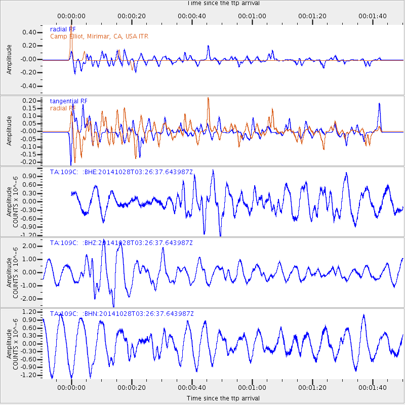
109C Camp Elliot, Mirimar, CA, USA - Earthquake Result Viewer
*The percent match for this event was below the threshold and hence no stack was calculated.
| Earthquake location: |
Tonga Islands |
| Earthquake latitude/longitude: |
-15.2/-174.7 |
| Earthquake time(UTC): |
2014/10/28 (301) 03:15:43 GMT |
| Earthquake Depth: |
35 km |
| Earthquake Magnitude: |
5.5 MB, 6.1 MWC |
| Earthquake Catalog/Contributor: |
NEIC PDE/NEIC COMCAT |
|
| Network: |
TA USArray Transportable Network (new EarthScope stations) |
| Station: |
109C Camp Elliot, Mirimar, CA, USA |
| Lat/Lon: |
32.89 N/117.11 W |
| Elevation: |
150 m |
|
| Distance: |
72.8 deg |
| Az: |
48.002 deg |
| Baz: |
238.516 deg |
| Ray Param: |
$rayparam |
*The percent match for this event was below the threshold and hence was not used in the summary stack. |
|
| Radial Match: |
62.489025 % |
| Radial Bump: |
400 |
| Transverse Match: |
39.472313 % |
| Transverse Bump: |
400 |
| SOD ConfigId: |
811962 |
| Insert Time: |
2014-11-11 03:54:59.316 +0000 |
| GWidth: |
2.5 |
| Max Bumps: |
400 |
| Tol: |
0.001 |
|
Signal To Noise
| Channel | StoN | STA | LTA |
| TA:109C: :BHZ:20141028T03:26:37.643987Z | 0.65223193 | 5.1812856E-7 | 7.943931E-7 |
| TA:109C: :BHN:20141028T03:26:37.643987Z | 1.37929 | 8.4118375E-7 | 6.0986724E-7 |
| TA:109C: :BHE:20141028T03:26:37.643987Z | 0.588375 | 1.620471E-7 | 2.7541466E-7 |
| Arrivals |
| Ps | |
| PpPs | |
| PsPs/PpSs | |


